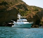
We left Costabaja at 0630 Sunday morning and were really impressed that the Nordhavn folks were up to see us off (Thanks, George, Jay, and Lisa). In addition, as we were pulling out we received a VHF radio call from our friends on Sunnysid…
Trawler Fest or Trawler Flop
In my last blog I mentioned my excitement in attending our first Trawlerfest. I knew something was going arye when our departure plans changed due to work commitments. Our initial plan was to arrive in Ft. Pierce on Saturday 01/22/11 and&nb…
Margaritaville!
We are in Key West, and boy does it live up to its reputation as a drunken party town! We arrived yesterday evening, and walked to the “hot” street, Duval St. So many open-air bars with live music, T-shirt shops, bars, souvenir shops, bars, and yes, Ji…
ANOTHER GLORIOUS DAY!
Just let me start with last night. Around 11:00 P.M., John and I were headed for bed when we heard this crackling sound. It was so quiet back in our cozy anchorage that you could hear this very plainly. It sounded like a fire crackling or maybe wat…
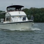
Legacy Harbor Marina, Fort Myers, Florida
Another absolutely beautiful day, sunny and warm. Went for a haircut this morning, we had made appointments on Saturday. The hairdresser seems to have done a good job. Went for a long walk around town this afternoon. Seems like there are many lawyers o…
Fort Myers
We’re 1/2 way through with our month stay here in Fort Myers and it’s been nothing but fun, fun, fun ever since we arrived. It’s a reunion every time a new boat of loopers comes into the marina. And the marina is located right downtown so it’s easy access to stores, restaurants, parks… Every day @ 5 boaters meet up at the tiki bar for cocktails and chatter.
The Edison Winter Estate is a short walk from the marina. We haven’t done the tour yet but plan to next week with Carol & Mitch on Serendipity. There is a statue of Edison, Ford & Firestone called “Uncommon Friends” displayed in Centennial Park downtown near the waterfront.

Walking around downtown I noticed the Florida Repertory Theater & invited two couples to join us for a viewing of “Sylvia” which turned out to be a very funny play about a very lovable dog played by a young woman. The show was so good it was written up in the New York Times.

Jim on Merried With Her has several antique Vets & wanted to take in the Muscle Car Show one day. It was a great place with all kinds of beautiful antique cars.


Here we are enjoying a 50’s style restaurant that is located in the car building.

One of the highlights of our Ft. Myers visit is our trip over to Sanibel Island. Part of the island has been set aside as the J.N. “Ding” Darling National Wildlife Refuge – a sanctuary for many species of wild animals, birds & native vegetations. We went along to the refuge with Mitch & Carol from Serendipity armed with our camera & binoculars. A tram ride took us 4 miles along Wildlife Drive making numereous stops to observe wildlife & learn many interesting facts from our guide. The area is full of red, white & black mangrove trees which actually play an extremely important role in supporting the ego system of the refuge. You can tell them apart by observing how far from the water they are growing. The mangrove tree leaves fall into the water & become covered with tiny microscopic things making the leaves very edible for birds, fish, & ducks. And, of course, the abundance of fish support the heron, egrets & white pelicans.


Our guide pointed out these shiny leaves on the vegetation which is the salt coming through from the salt water.

After lunch at the Sunnyside Cafe. we drove over to the Bailey Tract with another 2 miles of nature. Here’s an alligator’s path leading down to the water.

and here’s one of several alligators we saw –

Didn’t know there are tri-colored herons. You can pick them out by their white chests.

Mitch told us that these cute little turtles catching some rays are Peninsula Scooters

Another highlight of our visit here in Fort Myers was our tour of the Edison & Ford Winter Estates.
We started off with the largest Banyan tree in the continental US at a height of 84′ & 376″ in circumference along with a statue of Edison.

The estate is located on the Caloosahatchee River with a 1,500′ dock. Here’s a look down the shoreline.

And Greg took this really nice photo of palm trees that lead down to the river. There are almost 50 different types of palms on the estate.

The landscape of the estate today is still dominated by huge Ficus trees that were planted by the Edison, Ford & Firestone to find a viable source of rubber (latex) to grow in the region. The estate also includes 13 varieties of citrus, 12 varieties of bamboo & other exotic tropical plants like this Bird of Paradise.

For many years, Henry Ford visited Fort Myers at the invitation of his friend, Thomas Edison. Henry & his family stayed in the guest house. In 1916, the owner of the property next door wrote to Ford asking if he would be interested in purchasing the estate next to his friend & Henry did so for $20,000. After Edison’s death, Ford rarely visited Fort Myers & eventually sold the property.
The estate includes a museum which houses an impressive amount of Edison’s inventions including the phonograph, dictaphone, mimeograph machines & silent movies. Edison was almost completely deaf & a wooden cabinet shows his teeth marks which was the only way he could tell if his phonograph invention was working. Edison received a patent every year for 60 consecutive years.
On days we’re not sightseeing Greg’s busy working hard on cleaning & waxing the boat. The dinghy comes in handy for reaching the hull.

We finished off our month long stay in Ft. Myers with a bang! Our dear friends Pam & Rich who we traveled on the Loop with for 3 months drove 26 hrs. from Illinois to see us & other loopers in the area. Since they arrived on a Thursday they walked right into our weekly pot luck & since it was 4 º when they left home. Pam waltzed in with her big brown fur coat on. It was so good to see them again. Here we are at dinner with two other Looper couples – Carol & Mitch on Serepidity and Jay & Joan on Wind Song, Loopers who we met over the summer.

Pam & Rich

Mitch & Carol

Jay & Joan
My awesome family shocked me for my 60th birthday with my two daughters & granddaughter flying in for a long weekend. We had so much fun & then 2 weeks later my sister, Nancy, flew in which made my b’day celebration over a month long. My sister, Mare, was suppose to come too but was sick. We took everyone out on the boat across the river for a family gathering for my b’day.

Fort Myers
We’re 1/2 way through with our month stay here in Fort Myers and it’s been nothing but fun, fun, fun ever since we arrived. It’s a reunion every time a new boat of loopers comes into the marina. And the marina is located right dow…
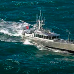
FPB 64 Iron Lady Launches
Let us introduce you to FPB 64-3, Iron Lady, about to start her sea trials.
Iron Lady is the first FPB 64 to have a stern extension bolted on. We will have performance numbers on this shortly and report them in due course.
Note the nicely faired buttock lines.
The rudder is huge relative to the steering loads […]
Music and Fleas
This post is about the Marathon Music Fest and the Big Pine Key Flea Market.The music was great this year (again). And all the logistical issues associated with the first festival last year have been fixed. Many (all?) local Krogen owners were voluntee…
Headless no more
After 3 attempts at snaking the hose for the back head I gave up and decided to take the end of the hose at the holding tank off. Will I cant remember the last time I vomited but its been a long time. What a mess to clean up.Well thanks to&nb…