Tag Archives | Nordhavn

WHEN DID YOU LAST CHECK YOUR INFLATABLE LIFE JACKETS

Envoy is currently in Lefkas marina for the Med winter.
Safety is a prime concern aboard Envoy and we aim to check all safety equipment according to manufacturers’ recommendations. But last year in Lefkas marina we had very-red faces when most of our pristine-looking inflatable life jackets failed their safety test. As well as foam-buoyancy offshore jackets we carry eight inflatable jackets fitted with crotch straps, retro-reflective tape, lifting rings, whistles and strobe lights. These all looked like new, some still in their original packing, and we wrongly assumed that because they’d only been used for drills without inflation and not used in the water they didn’t need testing. How wrong we were.
The inflatable jackets are all a well-known US brand and we’d never had them professionally tested during the seven years we’d owned Envoy before having them tested by Ionian Marine Safety (IMS) at Lefkas Marina in Greece. This turned out to be a wise and potentially life-saving decision, though one we should have taken much earlier. Imagine our shock when IMS’s Nikos Stamatakis reported that only two of our eight pristine-looking jackets passed the test. He apparently detected our surprise as he invited us to visit his workshop where he patiently explained the problems to us at first hand.
IMS service about 600 lifejackets and a similar number of life rafts annually, so Nikos is very knowledgeable and experienced. He explained that a lifejacket should be professionally checked annually, in particular after the first two or three years, and if well looked after could last up to 10 years. As lifejackets are likely to be our last line of defense in an emergency his advice sounds excellent, especially considering the small cost involved at €8 (about NZ$12) each for the two certified jackets and no cost for testing the failed ones. Nikos then showed us the problems with our jackets, explaining they are common faults.
The biggest problem occurs with the oral inflation tubes as they can tear away from the main body of the jacket, particularly as they age when the tubes become more rigid and exert more leverage. The tubes can also develop air leaks through their valves, even within a very few years from new.
Some of our jackets also had another common fault; air leaks through pinholes in the thermally welded jacket seams.
Many jackets are inflated using compressed air cylinders, and although our cylinders were like new Nikos showed us how regularly used jackets often have corroded cylinders that abrade and damage the jacket material causing air leaks.

Nikos shows Laurie a rusty air cylinder

For jackets with water activated inflation valves Nikos suggests replacement of their inflation bobbins every two years. Hydrostatically activated jackets don’t have this issue but are prone to invisible cracks in the transparent gasket joining the hydrostatic device to the jacket.
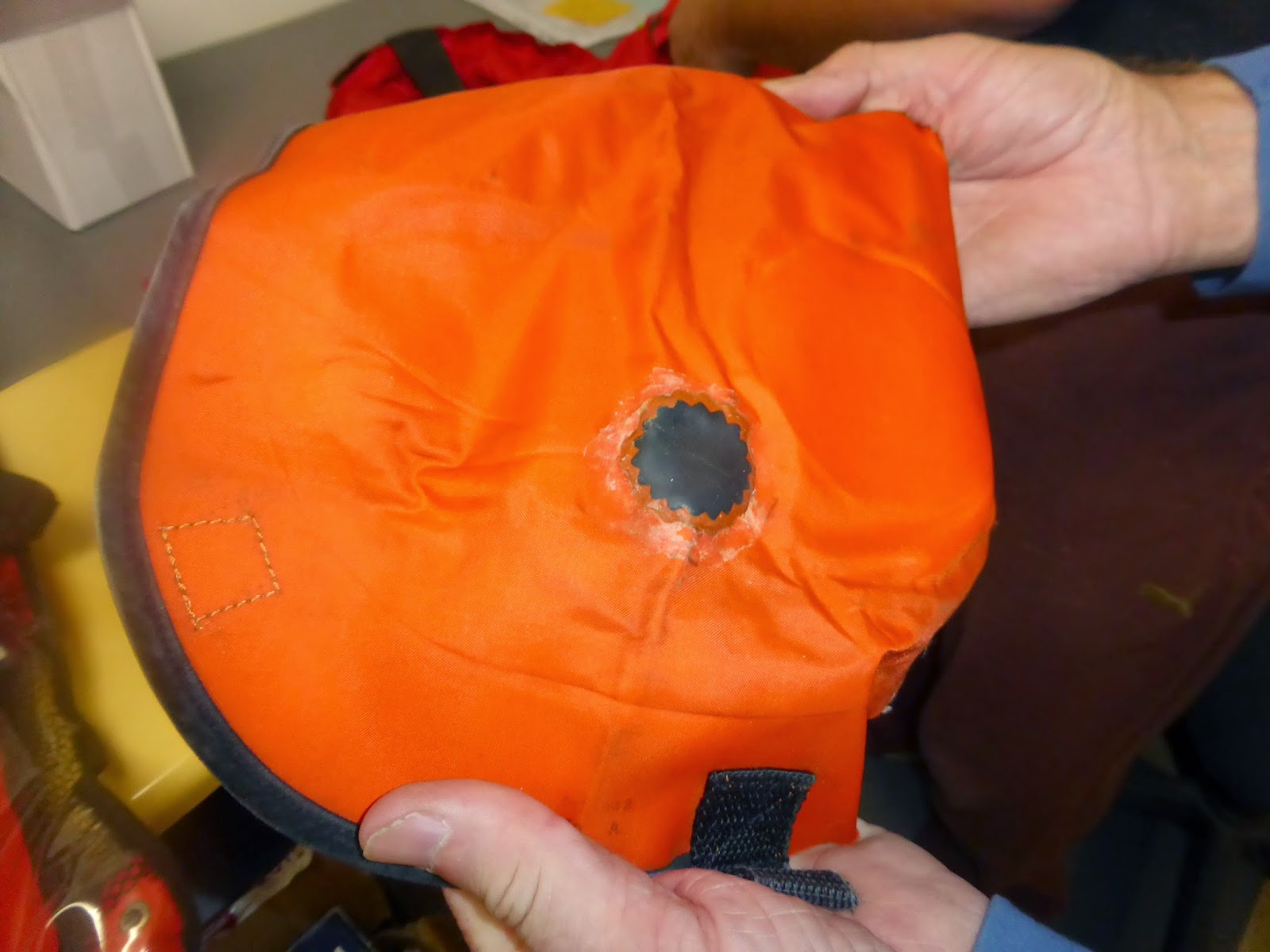
We also saw some jackets sent in for testing by other cruisers which had been incorrectly re-packed after use making them impossible to deploy quickly and safely. For example the straps, which are supposed to be left loose within the outer cover had been tied in bundles in an apparent attempt at neatness and this would have prevented inflation. Others had holes which had been patched using bicycle puncture repair kits – definitely not allowed.

Life jacket with “illegal” bicycle puncture repair

While there is no doubt that inflatable jackets are a great deal more comfortable and convenient to wear while moving around the vessel (because while not inflated they are very compact), we were surprised how fragile the jackets appeared to be when worn fully inflated, giving us the impression they could easily become damaged if snagged on a sharp protrusion – if we ever need to use them we’ll be taking some traditional style jackets along too.

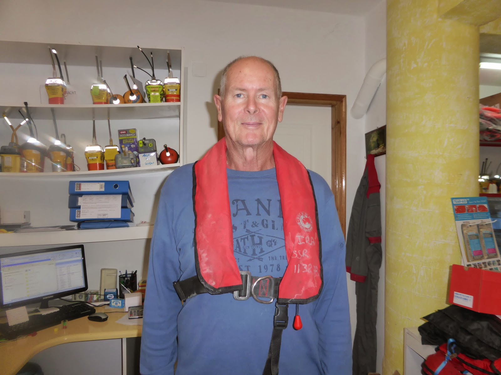
Laurie wearing a life jacket before inflation using the cartridge

And after

Nikos shows Laurie the correct arms position for jumping in the water with an inflated jacket, to reduce the chance of neck injury

LUCKY ENVOY

Envoy is safely tucked away at Lefkas Marina.
During February we received an email headed “Lucky Envoy” from Andreas of Sailand, the company looking after Envoy while she’s in the marina.
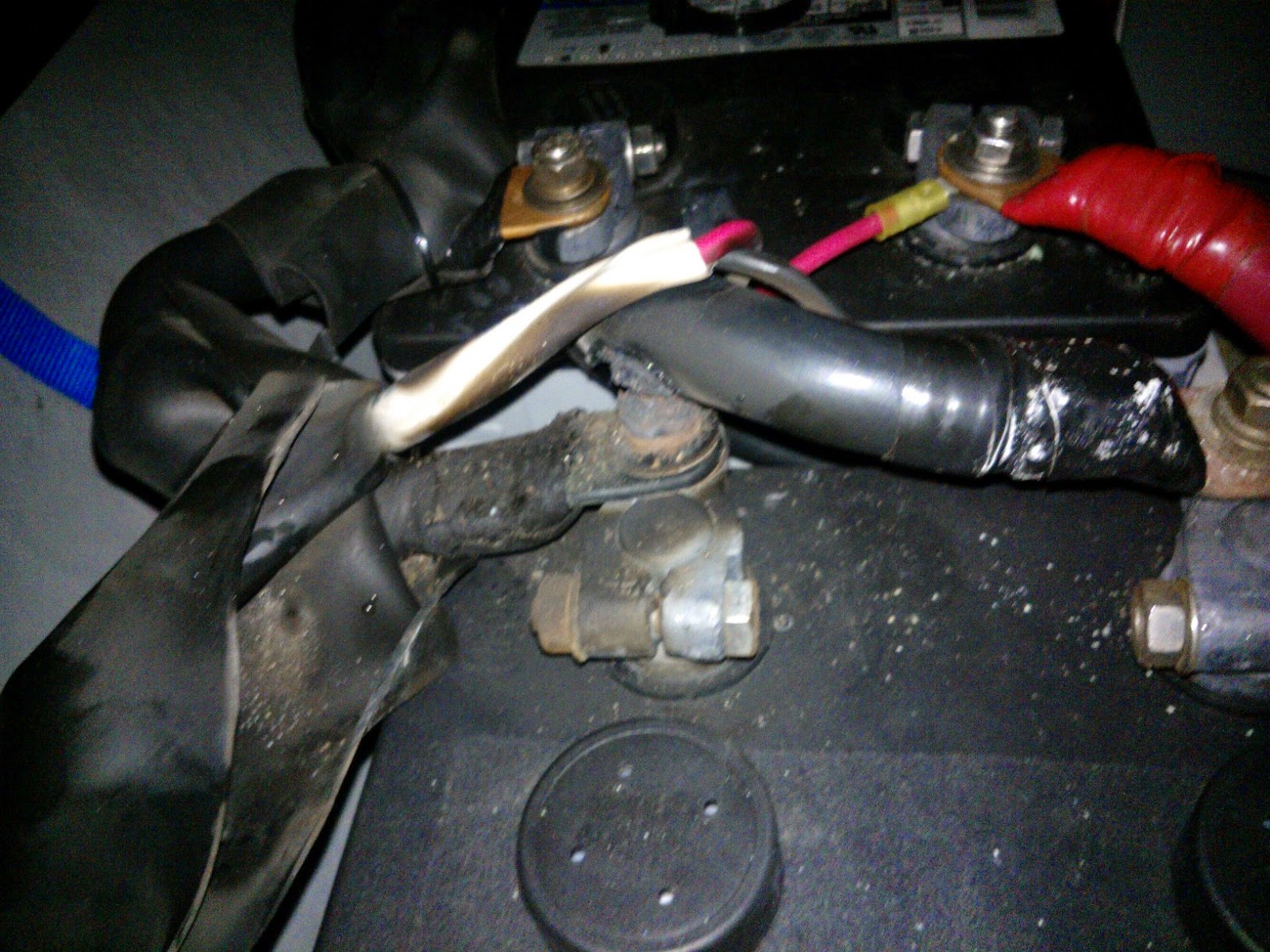
By way of background Envoy’s 12 volt start and house battery banks are charged from shore power through an isolation transformer to a 220 volt charger. However the 24 volt bow thruster bank has a 120 volt charger so needs to be charged using our inverter to generate 120 volts while the house bank is on charge. Andreas explained that when their electrician went aboard for a routine battery charge and turned on the inverter, he noticed a very significant increase in amps, leading him to inspect the bow thruster bank. On checking it he immediately noticed some heat coming from the battery bank so immediately turned the inverter off. A closer inspection revealed a positive battery cable, which had not been properly secured when this bank was installed in Turkey. It had rubbed against a battery terminal causing abrasion of the cable’s insulation and eventually a short circuit.
Andreas considers that had this not been noticed a major fire could easily have developed – hence the title “Lucky Envoy”. It’s reassuring to know the Sailand guys are alert and on the ball.

Abraded battery bank insulation nearly caused a fire

LOOKING BACK ON SIX YEARS OF LIVING THE DREAM – CRUISING THE MED (Part 5 of 5)

Envoy is currently at Lefkas Marina for the winter.
This is the last of a five part summary of Envoy’s six years Med cruising to date. The full article will shortly be published in Pacific Motor Yacht magazine.

How much does the live-aboard life cost?
Expect living costs such as food, beverages, household supplies and personal spending to be about the same when cruising as at home. Most other major costs including annual air travel to and from your boat, winter berthage, fuel, insurances and communications can be easily checked and budgeted for.

Many costs, such as winter storage, can be checked online and budgeted for

Over six years we have found repairs and maintenance to be our largest cost averaging about six per cent of the market value of our boat. This includes planned maintenance like oil changes and anti-fouling as well as the unexpected. The more you learn about your boat, the more you can do yourself to help reduce maintenance costs.

We have found repairs and maintenance to be the largest single cost

Have our early ideas and views changed and what would we do differently now?
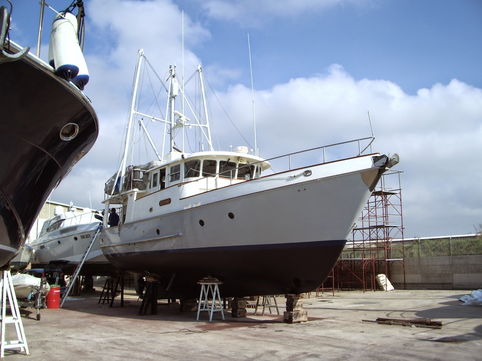
We are very satisfied with our Nordhavn 46 and when we purchased Envoy we had thoughts about cruising home to use her in New Zealand, but we’ve since decided to eventually sell Envoy with all her equipment in the Med.

If doing the same again we’d look more closely at semi-displacement mono-hulls and displacement catamarans, and we’d bring a lot less with us from New Zealand as nearly everything is available in the Med.

Envoy has proven a great vessel for our Med adventures to date

Initially we were reluctant to leave Envoy unattended and explore inland. This was a mistake and we now readily do so, particularly to share this experience with guests.

Would we cruise the Med like this knowing what we know now?
Absolutely – this has been one of the most truly amazing episodes in our lives. Our great experiences will be remembered long after costs have been forgotten.

Advice for anyone planning to live aboard in the Med
If you think cruising and living aboard in the Med (or anywhere for that matter) is for you, make your plans now – life’s time clock is ticking! Your biggest decisions will probably revolve around work, finances, what to do with your house and buying your boat. Don’t let life’s minor issues (e.g. what to do with the cat) stop you.
However we need to mention one area of practicality – it’s rare to meet long term cruisers in their prime working years or with school-age children.
Do your research by reading, visiting cruiser’s blogs and talking with live aboard cruisers.
Buy a boat which is well equipped for long periods of comfortable living aboard. Have your boat professionally surveyed and ensure she is financially unencumbered before purchase. Spend some time with the boat’s previous owner to start developing a detailed knowledge of her operation, systems, maintenance and spare parts requirements.
Familiarise yourself with relevant regulations – the Schengen Treaty currently limits visits by New Zealand passport holders to three months in each country and Australians to three months in the total of all countries. If you buy a boat which is non-VAT paid you may wish to avoid the need to pay VAT; for example Envoy is New Zealand registered and can remain in EU waters up to 18 months at a time without paying VAT. Before the expiry of the 18 month period it is only necessary to leave EU waters for a few days, and the 18 month clock is re-set. These are complex issues and specialist advice should be sought for each set of circumstances.
Turkey, Croatia and Albania now require cruisers to use agents for clearing in and out. Even where not required it’s often a good idea to use agents as they offer excellent advice on how to extend your stay and to minimise your obligations as mentioned above.
Participate in repairs and maintenance to reduce costs and expand your knowledge.
Don’t rely solely on cruising guides but do your own exploring to find your own special places. Leave your boat to explore inland by bus, train or rental car.
Don’t plan to visit every stretch of coast and every bay, but be selective and spend quality time at the places you visit to enjoy them fully, not superficially.
Anchor as much as possible as Med casual marina prices are expensive, typically 60-130 Euros (NZ$97-210) per night.
Have full internet access onboard to stay in regular contact with friends and family, for weather forecasts and technical information, and use a system like Rebtel to minimise your ‘phone costs.
Enjoy times with guests while sticking to your own cruising plans and expect your guests to come to and leave from where you are located at that time.

Where to now?
We don’t yet know where to from here, except to say that we have no plans to cruise beyond the Med and sometime within the next few years we’ll again be regular cruisers back in New Zealand.

THE ARGONAUT The South Island by Car Feb 18, 2015

THE SOUTH ISLAND

Crossing Cook’s Strait (Jan 20):   We left Wellington on the 8:30 AM ferry to Picton, a lovely little port on the north coast of the South Island just 13 miles across Cook’s Strait.   It was a clear, sunny day with calm seas (which can get very angry during the winter season) making the 3 hour trip delightful.  The ship weaved in and out of the lovely, picturesque islands which are in reality the tops of mountains that extend from north to south in New Zealand.  They are covered in green grass or forests, depending on the microenvironment, and the gorges in the steep hillsides provided little bays, some of which had a building or two marking a town’s site.  The ocean was a brilliant blue, and everything was clean and clear.   It reminded us of our trip through Desolation Sound in British Columbia aboard Odyssey in 2011.   

Driving to Abel Tasman Park:  We disembarked in Picton and picked up our new rental car.  From Picton we drove west for about 4 hours to a little town of Pohara on the Golden Bay, the western gateway to the Abel Tasman National Park.  The two lane highway took us through part of the Marlborough wine region on the north coast.  The geography here is similar to northern California, with broad valleys bordered by low mountains that are covered with forests.  The famous vineyards of Cloudy Bay and Oyster Bay, among others, are spread out across the valley along with large cattle farms.  The flat plane of the valley floor is broken up by wind breaks of high hedges, Lombardy Poplars, or rows of pine trees.   As we drove along we eventually came to the end of the valley, then ascended a windy, hair-pinned curved road over the mountains to the next valley.  The drive over the mountains provided stunning pastoral vistas: views of rivers flowing through the valleys and herds of animals grazing lazily in the warm sunshine.  The roadside was carpeted in colorful wildflowers of orange, yellow, and purple.  We stopped at the little town of Havelock for lunch and as we entered the café we spotted a couple we knew: Leslie and Don Brown from Trueblue, a 65 ft. Oyster sailing yacht we met in Papeete and again in Vava’U.  What a surprise: they were touring the country by motorcycle!  After a nice lunch including a bucket of Green Lip Clams each the size of an egg, we were off again.

As we continued along, the highway began to skirt Tasman Bay at the city of Nelson, an artist colony and resort town at the eastern entrance to the park.  Here golden sand beaches were the largest I had ever seen, and people by the score took full advantage of the fabulous sunny weather and ocean surf.  An hour or so more down the road brought us to Takaka a few more miles further to our hotel in Pohara on the shores of the Golden Bay.  Our hotel was a nice little spot run by a New Hampshire transplant and his partner.  From this base we explored the park, but more importantly Cape Farewell and the Spit. 

Cape Farewell and the Spit (Jan 21):  Cape Farewell is the northwestern most point on the South Island and it is named for the countless seafarers who bade farewell to their loved ones as they went to sea.  The cape itself is a beautiful promontory of greywacke rock, and the “Spit” is a finger of sand that extends 36 km. north and encloses the Golden Bay by its eastern flank.  The Spit is growing, as it has for thousands of years.  It was formed by sand carried north by ocean currents from points south on the South Island’s coast.  The sand comes from the erosion of New Zealand’s Southern Alps.  The Southern Alps are made of rock that has been pushed up by tectonic plate forces as the Australian Plate folds under the Pacific Plate.  The plates slide against one another: the resulting fault is the boundary of the plates and can be seen from space as a rift line falling on the western side of the Southern Alps and extending in a straight line from northeast to southwest. The fault is often the site of large lakes lying within the mountains of New Zealand.  On the western side of the fault the mountains are made of granite or dolomite from the Australian-Indian Plate, on the eastern side the rocks are greywacke, sandstone, limestone, rock and mud or sea floor strata from the Pacific Plate.  Ancient creatures from the Cambrian are fossilized in some rocks, while others date from the Earth’s original Gowanda continent a billion or more years ago.  The last ice age ended about ten thousand years ago, but for perhaps one hundred thousand years, massive glaciers two or three miles thick crushed the mountains and carved out New Zealand as we see it today.  The glaciers ground the stone and as the glaciers melted rivers formed that brought the stone to the ocean’s shore.  The glaciers piled up huge moraines that radiate outward from the central mountains and look like mountains themselves.   The ancient riverbeds of gravel, perhaps 400 feet deep, formed the plains that are the agricultural heartland of the country.  The plains of the south island are largest in the east and southern portions of the islands, and are narrower on the western side of the mountains.  When driving around New Zealand, one of the most fascinating things I have found is that the geologic history of the world is all laid out before you, with different ages apparent around almost every turn.  It is all simply breathtaking!

Plate tectonics is forcing the mountains up about one inch per year, but erosion diminishes them by about the same amount.  The tops of many mountains are huge gravel fields.  As the mountains are eroded by wind and weather sand is created, the mountain streams carry the sand to the Tasman Sea, sea currents carry the sand north to Cape Farewell where a counter current causes the sand to be deposited forming the Spit.   

Our tour was conducted on a large bus especially customized to be a four wheel drive, oversized dune buggy. Our tour lasted about eight hours; we drove 30 km down the Spit to an old light house.  There the tour operators provided tea and snacks as we walked around the enclosure that once was home to the lighthouse keepers.  We made several other exploratory stops along the way to examine interesting things like Fur Seals, the Gannet colony, and to climb the beautiful dunes and explore features of the beach.  The life along the Spit was very interesting, particularly the bird life, such as seeing Oyster Catchers and Gannets.  Touring the Cape Farewell Spit was one of the most interesting things we have done.

Driving to Arthur’s Pass (Jan 23):  The drive from tiny Pohara on the northern coast to Wilderness Lodge high up in Arthur’s Pass was a nine hour trip across the northwestern quadrant of the South Island.  It started with a 20 km winding trip across the Arthur Range of Mountains which are high and very beautiful with lush, verdant greenery.  Wildflowers carpet the sides of the road and large limestone massifs inspire awe as we whipped around hairpin curves avoiding giant double tandem lorries.  The scenery was remarkable.  We descended the mountains into the Tapawera River Valley to find large dairy and sheep herds grazing on beautiful pastureland.  We followed Highway 6 over hill and dale through the valley for several hours until we reached the coast of the Tasman Sea at Westport.  Along the way we picked up Simon, a young (24) lad from Salzburg, France, who had left home after his mother died of cancer three years ago.  His father died at sea when he was age 13.  Simon had traveled first to Kazakhstan, then to India, Myanmar, Thailand, Cambodia, Laos, and Vietnam before coming to New Zealand.  He was a very intelligent young man, but he said he had no reason to return to Europe or France (as he seemed to have no one to love or care for him there). He told us of his experiences twice being robbed of his backpack at knife point and being cheated by temporary employers or hostel owners.  He asked me all sorts of questions about investing his inheritance of $20K euros. It seemed so sad to us that he wanders the world by himself without anyone to care about him or know where he is.   One thing we did learn from Simon: backpackers don’t shower much and Rebecca was forced to keep the A/C on full blast to provide relief for her delicate olfactory senses! 

At Westport we turned south and followed Highway 6 to Greymouth.  This part of the South Island is covered in rainforest.  Here they get plenty of rain, 6 -7 meters of rain per year.  It rains 25 days a month here, but fortunately we are traveling during a dry spell, so the sky is clear and beautiful.  The road winds around the shoreline with the mountains and beautiful, lush fern forest on our left and the Tasman Sea on our right.  The sea water is a beautiful grey-blue color unlike any I have ever seen. Perhaps the sun reflects off the sand bottom or the suspended sand in the water being carried north as I described above.  As we drove south we came to the “Pancake Rocks”, a very unusual rock formation jutting out into the sea.  The rocks look like chimneys of very thin stacks of pancakes.  We spent an hour here and it was fascinating.   A picture is worth a thousand words, so I will direct you to the website picture gallery to see them.

An hour or so further down the road brought us to Greymouth, a major crossroad on the island: it connects Christchurch on the east coast with the west coast via both rail and highway.  At this point we bade farewell to Simon and turned east up highway 73 toward the little town of Arthur’s Pass and the Wilderness Lodge. 

New Zealand Roads:  In New Zealand there aren’t any super highways, just two lane roads that were built in the 60’s.  Both the scale of the roads and their engineering are very basic. The construction is gravel over bitumen.   As the whole country is mountainous, rivers and creeks transect the land and bridges are frequently required.  Bridges in New Zealand are almost always one lane, and a sign on the road tells you which direction has the right of way.  The roads are narrow, and the bridges are often narrower.  Roads are very curvaceous: straight sections rarely extend for more than ½ km.  When driving up or down a mountain the road follows every bend, twist, and curve of the mountain side and they are steep, too, sometimes with 160 slopes.  Some curves have signs reducing the speed limit to 10 km!  That’s how sharp the turns can be.  Mountain scenery is fabulous anywhere, but these roads help the traveler get up close and personal with the mountains.

The Wilderness Lodge (Jan23):  Arthur’s Pass is the only pass across the Southern Alps in the central part of the South Island.  The Alps are 10,000 ft. or more in elevation and the peaks are snow capped  all year around.  They are beautiful, spellbinding, majestic peaks of rock.  The western slope is forested and green, but the eastern slope and the Dunstan Range to the east are much dryer and arid.   In fact 60% of New Zealand is arid or semi-arid land.  The drive from Greymouth to the Wildness Lodge is almost halfway across the island.   The lodge is a combination sheep station, cattle ranch, and eco lodge.  The sheep station raises Merino Sheep, noted as the world’s finest grade of wool.  As we were shown about the station and introduced to several sheep, we were told that a human hair is 60 microns, carpet wool is about 25 microns, but Merino Wool is just 18 microns or less, making it very fine indeed.  It is used in Smart Wool and Ice Breaker brand garments.

When we arrived at the lodge we were met by Michael who manages the property and is the son of the owner; he was very friendly and helpful.  The lodge offers hiking and kayaking as primary activities, and includes guided morning and evening hikes in the nearby Beech Forest.   A five course dinner is served after a social hour in the evening, and a full breakfast is prepared in the morning.  The first day we took a half-day kayaking trip to a mountain lake and packed a picnic lunch to enjoy on the shore. The next day we tramped (in NZ you can tramp or trek, but you can also walk or hike) about the Beech Forest with a guide, and later in the day we drove to tiny Arthur’s Pass Village for lunch.  We enjoyed the company of fellow travelers, Margo and Paul of Saskatchewan, who were very good company and experienced travelers with whom we traded travel recommendations.  The third day was ostensibly my birthday; ostensibly because it depended on which hemisphere I chose to use as the time to be observed, so I chose both!  How lucky to celebrate a really big birthday literally at the top of the world (in the Southern Alps) and feeling that it is a metaphor for the way my life has turned out.   Anyway, we tramped for about 90 minutes across a paddock (pasture) to the Mountain Gorge Trail, which took us up a riverbed and though a Silver Beech Forest.  The forest was graced with many types of ferns, moss, lichens, fungi, tiny colorful textured seedlings, and beautiful large trees. The riverbed was strewn with rocks and boulders with a light grey coloration and uniform appearance through which ran a gurgling stream of cold, pristine mountain water.  It was so lovely – I am running out of adjectives to describe the beauty of New Zealand – it is hard to imagine or describe.  What a wonderful way to spend a birthday!  After a wonderful dinner and chorus of Happy Birthday, the next day we departed the lodge for the Franz Josef Glacier, about four hours to our south. 

One night while we were having dinner, Rebecca became alarmed by the sight of not one, but two mice chasing about near the kitchen.  She asked that something be done but Alan, the guide, said that the forest was experiencing a population explosion of mice and nothing could be done.  Mice were everywhere! This didn’t comfort Rebecca at all, but the next day at the hotel in Franz Josef we bumped into a couple who were with us at the Wilderness Lodge.  The lady told us that mice had gotten into her room and tried to open a bag of nuts she had near her suitcase.  She apparently tried to rouse her husband to handle the problem, but he just turned over and went back to sleep.  She thought she chased the entire family of mice out of the room, but the next morning she found one in bed with her! Later in the day when she arrived at the Franz Josef hotel she found another live mouse in her daughter’s suitcase and was absolutely outraged!  She wasn’t too happy with her husband either! We asked if she asked for a refund from the lodge, but she hadn’t and didn’t know the price of the room.  When we told her, she immediately got in touch with the lodge and they refunded her the cost of the rooms.  He husband, who was a good natured fellow, also took a hit.

The Franz Josef Glacier (Jan 27):  Franz Josef is a little faux, alpinesque tourist town located south along the coast in the rainforest region.  Here tourists flock to see a glacier and we were no exception.  It was a five hour drive from the lodge, and it was also January 26 in the western hemisphere.  I couldn’t put it off any longer, it was my birthday for sure.   We checked into a nice hotel that offered a second story view of the rainforest and high speed internet as well.  Wow! Back in civilization.  Rebecca lined up a surprise spa afternoon for me complete with massage, pedicure, and bar service.  It was completely relaxing and topped off with a cigar, champagne, and a wonderful dinner.  It’s good to have a birthday.

White Herons:  The next day we drove to Whataroa and the White Heron Bird Sanctuary.  There are only about 200 snowy White Herons in New Zealand (an endangered bird) and they only nest along a 50 meter stretch of the Whataroa River deep within a virgin rainforest sanctuary.  We took a tour bus to the river and then a hair raising jet boat run to a boat landing 16 km into the sanctuary.  Once off the boat, we walked another 500 meters or so through the rainforest until we reached an observation blind; from there we could see across the river to the White Herons on their nests with many hatchlings under their care.  These are beautiful birds with special mating plumage of delicate thin white feathers in full display.  It felt like we were in a secret, special place in the wild kingdom reserved for just a lucky few, and we were glad to be here.

The Glacier:  That afternoon we took a two hour walk to the glacier.  It has been receding about 70 inches a day, so in a few years it will exist only at the top of the mountain and may not be visible from below.  At one time it filled the valley and extended far out into the Tasman Sea.  It has receded about a mile in the last ten years.  The little village of Franz Josef is literally abuzz with the sound of helicopters ferrying tourists for $329 a pop up to the clouds for a bird’s eye view.

The next morning we broke camp and headed toward Queenstown, the tourist mecca of the South Island.  But first we had a two day stopover at another Wilderness Lodge on Lake Moeraki, this time to explore the costal rainforest.

Lake Moreaki Lodge (Jan 29): This lodge is owned by the same family that owned the lodge at Arthur’s Pass.  Gerry McSweeny, Michael’s father and lodge owner, sought us out for a personal visit, perhaps owing to the mouse issue.  Gerry is a very nice guy and during our conversation asked me if I had seen the book on Michigan in the library.  He then went on to name a few places in Michigan like the Mackinaw Bridge and the Wolverines of the University of Michigan.  I told him I hadn’t seen the book and I inquired as to whether he had ever traveled to Michigan. No, he said, but he had a guest from Michigan who came to the lodge three times with his young wife Cathy…his name was Bo Schembechler! 

The lodge was located in the rainforest, and Rebecca and I spent a few hours one morning on a tramp through the rainforest to the ocean.  It was a walk we will never forget.  The forest looked like a set for The Ring Trilogy or The Hobbit- mystical and mysterious.  It is damp, as you might expect a rain forest to be.  The canopy trees are large, 1,000 year old pine trees that stand 150ft. or more above the forest floor.  In their limbs are mosses, lichens and all manner of ferns and fungi.  Lower down live the giant tree ferns, perhaps 20 feet tall, with their fronds spread out like giant umbrellas.  Then Beech trees and their seedlings, along with what we call ostrich ferns and other tropical plants and vines occupy the forest.  Of course many ancient trees have fallen and are now part of new life emerging from the forest floor, which is covered in sphagnum moss as thick as a carpet.  Nestled in amongst the plants are little flowers, or emerging ferns bright with a lighter shade of green.  The name of the path we followed was the Monro Beach Trail and after an hour of walking up hill and then down to the beach, we reached the Tasman Sea. This is a beach were Penguins come to breed and raise their young during their mating season.   However, when we were there the only life we saw were tiny Sand Flies and they are as nasty as any swarm of hungry Mosquitos. 

Our Drive to Queenstown (Jan 31):  The next morning we got up and going after bidding farewell to Gerry and Ann and the guests we had visited with during our stay.  Our drive to Queenstown was 265 km.  It began with a two hour trip through the rainforest of the Mt. Aspiring National Park, a World Heritage Site, on the west coast of the South Island.   The scenery was once again spectacular.  At about the 90 km mark the road turned inland as it crossed the Southern Alps.  On the western slope the vegetation is verdant and lush.  As we ascended we reached a point where the vegetation turned tawny brown and shrubs replaced trees.  Some of the mountainsides were barren and very steep.  As we drove along, huge sweeping vistas of rock ledges and outcrops on the mountains came into view.  The mountains enclosed surprisingly large lakes some of which were over 50 km long (Lake Wanaka and Lake Hawea) which, as I mentioned above, are the faults marking the point of contact between the Pacific and Australian Plates.  As we progressed we entered the Otago region of New Zealand which is noted for these beautiful conditions and, like Napa and Sonoma Valleys, supports a thriving fruit and viticulture industry.  Occasionally we would see high fences enclosing a paddock (pasture), within which were Red Deer that are being raised for the venison market.  They are much larger than our White Tail variety, and are offered on the menus throughout New Zealand. 

Queenstown (Feb 1):  After about 6 hours of driving though some of the most spectacular scenery on earth we arrived at Queenstown, located in middle of the Southern Alps.   The little town is situated on Lake Wakatipu, a crystal clear lake about 60 km long and surrounded by mountains of differing shapes including rock massifs, striking pyramidal shapes, and high mountains that slope to the lake.  The lake itself is in the basin of the rift formed by the Pacific and Indo-Australian Plates.  Some of the mountain sides are arid, some are forested, some are semi-rainforest, and some are covered in shrub: it all depends on the micro climate.   The town itself hangs on the hillsides around a bay: it is a lovely setting featuring a spectacular view of the snow covered, rocky peaks of the Remarkable Mountains.

Queenstown is a resort for vacationers from Wellington and Auckland who flock here particularly during the winter ski season and the summer holiday period in January. The hills are covered with very nice holiday homes and the area near the lake has copious numbers of small hotels and condos.  The town is also a sort of “Fort Lauderdale” for Chinese kids from Beijing, who can take direct flights to Christchurch and then hop local planes to Queenstown.  The 18 -30 year set likes to party hearty here during the Chinese New Year’s celebration in mid-February.  They love the town center with its shops and restaurants that cater to the inexperienced.

We stayed in a lovely hotel right on the banks of the lake facing the Remarkable Mountains and their unforgettable vista.  At many hotels breakfast is included with the room tariff, and that was the case with this hotel.  Rebecca and I came down to breakfast the morning after we had arrived and sitting near us were four scruffy looking men in their late 60’s; they really looked “rode hard and put away wet”.  Tattoos, long stringy grey hair, earrings, and cloths that looked as though they were carefully selected for a particular “look”.  Then I remembered that we passed a huge number of cars and busses parked in a field near a stage that had been set up near a hillside that could be used for an amphitheater.  Hundreds of people were waiting in the hot sun for the show to start.  What was the attraction?  None other than Three Dog Night (e.g., Just an Old Fashion Love Song), and yes, these dudes were sitting right next to us for breakfast talking about stage lighting! 

Milford Sound and the Fiordlands:  The next day we took a tour to Milford Sound, which is really a fiord because it was created by a glacier not a river.  Our trip was by bus, which we chose because we were told the drive to the sound was very dangerous, but apparently our advisors were not familiar with what we had already driven through.   Anyway, we took the bus tour and it included overnight accommodations aboard a small ship designed for fiord tours.  The bus drive was about 6 hours and provided a trip with out-of-this-world scenery.  Queenstown is surrounded by mountains. As we traveled south, the landscape broadened; the mountains spread out to a broad plane glacial plane.  The fields became flat and the mountains subsided into rolling hills except at the boundary of the plane.  Large herds of sheep, cattle, and deer were contentedly grazing on lush green pastures on hillsides and mountain slopes.  It was a perfect, if not a heavenly, pastoral scene.   

After several photo and comfort stops the bus finally made it to the Milford Sound National Park, a World Heritage Site.  The afternoon was cloudy and rainy, but at the time we didn’t know it was perfect for seeing the fiords.  As we ascended the torturously curved roads into the clouds only 3,000 feet above sea level, we entered the world of the glacier and some of the most spectacular formations on the planet.  Huge mountains perhaps 10,000 feet above sea level had been literally carved, cut and ground into the sharp gorges and fiords that we entered.  The mountains rose vertically from the floor of the canyons or the sea straight up to the clouds.  Rain fell and that which fell onto the mountains was transformed into veils of falling water in hundreds of falls over miles of vertical mountain massifs.  When the rain stopped the waterfalls disappeared. 

We spent the night aboard the Mariner, a 100 ft. vessel designed to accommodate 100 tourists on just this sort of tour.  The ship took us about three miles out into the fiord, stopping at different places and positioning the bow into one of the giant waterfalls so that the water tumbled onto the ship.  Later the ship anchored in a little bay and dinner was served.  Our tablemates, George and Mary were from England and he was head of Britain’s fifteen nuclear power plants.  He had just retired.  It was interesting to talk with him about the controversy surrounding nuclear power: Germany’s recent decision to close of all of its plants, China’s plan to build hundreds of them, and Japan’s Fukushima disaster.  He feels the technology was safe but Japan is a closed society in many ways, including the fact that Japan does not participate in international professional groups or permit oversight bodies to help them manage their reactors.  This led to the disaster and cover-up.

The next day the sun came out and revealed a spectacular day; we got to see the glorious mountain scenery but this time it was in the full sun.  By late afternoon we had arrived back at our very nice hotel in time for a lovely meal in their very fine restaurant. 

Queenstown has a downtown area, perhaps a bit more developed than most towns, but nevertheless typical of New Zealand towns.  There are no shopping centers like we have in North America, rather their city centers are like the main streets we used to have: small shops, for the most part locally owned, with all sorts of businesses occupying store fronts.  Of course there are lots of restaurants and bars in this resort city.

Queenstown to Christchurch (Feb 5): The drive to Christchurch was a long one, about 400 km across the backbone of New Zealand.  I thought it would be mostly mountain roads, but it turned out to be smooth sailing once we got over the Southern Alps.  Unlike the green rainforest and lush grassland along the western coast, the Otego and Canterbury regions are semi-arid grasslands that look a lot like northern California in some places and like Nevada in others.  As we drove eastward the mountains turned to large rolling hills with the most interesting formations, then to flatlands created by the glacial rivers millenniums ago.  High in the mountains were the large sheep stations, and as the angularity of the land subsided, cattle herds predominated.  New Zealand has about 75 million head of cattle, and 45 million head of sheep.

Christchurch is the largest city on the South Island with a population of 350,000.  In both 2010 and 2011 it suffered magnitude 8 earthquakes.   The damage was horrific: the entire city center was destroyed, including priceless Gothic Revival buildings, modern fifteen or twenty story office buildings and hotels. Many large buildings are still standing, but are surrounded by fencing to keep people away from them in case they were to fall.  The Anglican Cathedral, which dominates Cathedral Square in the center of town, is now partially destroyed and in ruins.  The residential areas were not spared: about 20% of the homes were destroyed.  In the Fukushima earthquake Japan suffered a loss equivalent to 3% of its GDP.  In the case of Christchurch, New Zealand is estimated to have suffered losses valued at 10% of its GDP.  Despite the destruction Christ’s College, with its beautiful Gothic Revival buildings constructed of grey stone walls and limestone window and door sills, remains.  These buildings adjoin the beautiful and world renowned botanical gardens that lie beside the Avon River as it meanders through the city.  We enjoyed the morning walking through the gardens and the afternoon walking around the rest of the center city.

The next day we took the Transalpine Train across Arthur’s Pass to Greymouth and back.  While this was a somewhat redundant trip given that we had spent several days in the Pass at Wilderness Lodge, it afforded one last look at these fabulous mountains from a different perspective. 

Christchurch to Marlborough (Feb 8): It is a four hour drive north along the rocky, picturesque coast to the little city of Blenheim, heart of the New Zealand wine industry.  Here are thousands of acres of grape vines under cultivation producing the famous Sauvignon Blanc grape among others.  Names like Cloudy Bay and Oyster Bay, so familiar to we wine drinkers, dot the countryside.  Touring and tasting the produce occupied us for most of a day and we learned, among other things, that the first vine was planted here in 1979.  In just thirty-five short years a colossus was established. 

We stayed at the Straw Lodge, a small 21 acre organic vineyard and B&B in the middle of the valley.  Trudy and Barry Gainford bought the farm last year and work it with their son-in-law.  They immigrated to NZ twenty-one years ago from South Africa.  Barry is an optometrist turned grape farmer, and he and his son-in-law (formerly an accountant) now run the operation.  Their first harvest was last year.  Barry grows Sauvignon Blanc and Pinot Noir.  Of the 21 acres 16.5 is used for farming, the other acreage is used for roads and buildings.  Each cultivated acre produces about 1 metric ton of grapes, which he can sell for about $18,500.  Barry told me that he can bottle the wine and sell it for around $20-30/bottle, and it would cost about $4 a bottle to have it processed including the grapes, processing, and the bottle.  Each bottle takes 1 kg of grapes, so his property could produce about 16,500 bottles of wine.   The profit is potentially much higher before considering marketing expenses.  So the whole key to higher profits is to leverage some sort of marketing plan for his small winery in conjunction with other growers.

One morning Trudy asked me if I had ever heard of “green eggs and ham”.  What father hasn’t heard of that?  I thought it was just a fantasy of Dr. Zeuss, but Trudy told me there is a breed of chicken that lays a greenish egg called an Araucana Chicken and Trudy had a few.  She brought me the egg and compared it to a brown egg, and indeed it was a greenish blue.  It was about the size of a duck’s egg and very delicious I might add.  So indeed, I had Green Eggs and Ham that morning at the Straw Lodge! 

During the day we toured the little towns in the area, lunched at a winery and tramped a trail along the Queen Charlotte Sound.  It was a lovely time and very interesting.  Our tour of the South Island now complete, we rose early the next day, enjoyed a wonderful breakfast at the Straw Lodge, drove to Picton,  took the ferry back to Wellington and the highway north toward Auckland. 

Kingsgate and Lake Taupo (Feb 12 -14):  Our first stop that night was in the town of Kingsgate on the Wanganui River at the Sea of Tasman coast, after a three hour drive.  It was a good size town with an interesting main street, on the cliff across the river overlooking the town stood a very large, brown stone tower about 130 feet high that commemorated the soldiers of WWI, captioned the Great War. 

The next day we drove about four hours northeast to the town of Taupo, situated on the coast of New Zealand’s largest lake.   It was a very interesting drive across tortured ground that is the fault rift marketing the boundary of the Indo-Australian Plate and the Pacific Plate.  As we neared Lake Taupo we could see one of three snow caped volcanos that mark this site as a World Heritage Site.  Eventually we could see all three volcanos lined up in a row, with Lake Taupo in the same rift line as the volcanos.  It was one of the most interesting and gorgeous geologic sights I have ever seen, and desolate as well.  Two of the three volcanoes are cone shaped, about 7,000 feet high, and formed of a purple brown rock. There was nothing living on the sides of these mountains.  The third volcano was much bigger and was crowned with eight glaciers.  It was massive.   Surrounding them was hundreds of square miles of colorful arid landscape.  It is seldom that one can see one of the active sites that is currently forming our planet. 

We stayed at the Lake Taupo Lodge, a lovely five room small hotel that has hosted Barbra Streisand, Burt Reynolds, and other celebrities.  Lake Taupo and environs is one of the premier trout fishing spots in the world, with Rainbow and Brown Trout so large they look like Salmon.  I am hoping to return in April for a taste of New Zealand fly fishing.

A Few Miscellaneous Observations: 

  • Most homes are small and unpretentious, I would guess 1,400-2,000 sq. ft.
  • There are no billboards along the roads of NZ, making it even more beautiful
  • There are a lot of Japanese cars here. Like Jamaica, the Japanese sell their off-lease cars here at a reduced cost.  (If you recall from a previous blog, Samoa changed from left hand to right hand drive to take advantage of the Japanese used car market.)
  • There are a lot of foreign kids backpacking and doing summer work in NZ. They can easily obtain a 1 year work/travel visa here.  Unfortunately, we don’t do this in the U.S.
  • The Kiwis use the words “pop” as in pop in for a moment, or, I’ll pop around this afternoon, and “sort it out” as in ”Call your insurance agent and he will sort it out for you.” They often use the word sort when there is nothing to sort out, like:” I left the key in the room.”  The hotel clerk reply’s, “that’s OK, I’ll sort it out.”  The Kiwis pop and sort all kinds of things all day long! 
  • Kiwis’ do not have a tort provision in their legal code, so you cannot be sued for negligence. This has some unexpected ramifications, for example, tubs and showers are slippery, and pedestrians are in real danger as drivers will run you over if you are in their way.

We will post some pictures as soon as we have some bandwidth.

THE ARGONAUT The South Island by Car Feb 18, 2015

THE SOUTH ISLAND

Crossing Cook’s Strait (Jan 20):   We left Wellington on the 8:30 AM ferry to Picton, a lovely little port on the north coast of the South Island just 13 miles across Cook’s Strait.   It was a clear, sunny day with calm seas (which can get very angry during the winter season) making the 3 hour trip delightful.  The ship weaved in and out of the lovely, picturesque islands which are in reality the tops of mountains that extend from north to south in New Zealand.  They are covered in green grass or forests, depending on the microenvironment, and the gorges in the steep hillsides provided little bays, some of which had a building or two marking a town’s site.  The ocean was a brilliant blue, and everything was clean and clear.   It reminded us of our trip through Desolation Sound in British Columbia aboard Odyssey in 2011.   

Driving to Abel Tasman Park:  We disembarked in Picton and picked up our new rental car.  From Picton we drove west for about 4 hours to a little town of Pohara on the Golden Bay, the western gateway to the Abel Tasman National Park.  The two lane highway took us through part of the Marlborough wine region on the north coast.  The geography here is similar to northern California, with broad valleys bordered by low mountains that are covered with forests.  The famous vineyards of Cloudy Bay and Oyster Bay, among others, are spread out across the valley along with large cattle farms.  The flat plane of the valley floor is broken up by wind breaks of high hedges, Lombardy Poplars, or rows of pine trees.   As we drove along we eventually came to the end of the valley, then ascended a windy, hair-pinned curved road over the mountains to the next valley.  The drive over the mountains provided stunning pastoral vistas: views of rivers flowing through the valleys and herds of animals grazing lazily in the warm sunshine.  The roadside was carpeted in colorful wildflowers of orange, yellow, and purple.  We stopped at the little town of Havelock for lunch and as we entered the café we spotted a couple we knew: Leslie and Don Brown from Trueblue, a 65 ft. Oyster sailing yacht we met in Papeete and again in Vava’U.  What a surprise: they were touring the country by motorcycle!  After a nice lunch including a bucket of Green Lip Clams each the size of an egg, we were off again.

As we continued along, the highway began to skirt Tasman Bay at the city of Nelson, an artist colony and resort town at the eastern entrance to the park.  Here golden sand beaches were the largest I had ever seen, and people by the score took full advantage of the fabulous sunny weather and ocean surf.  An hour or so more down the road brought us to Takaka a few more miles further to our hotel in Pohara on the shores of the Golden Bay.  Our hotel was a nice little spot run by a New Hampshire transplant and his partner.  From this base we explored the park, but more importantly Cape Farewell and the Spit. 

Cape Farewell and the Spit (Jan 21):  Cape Farewell is the northwestern most point on the South Island and it is named for the countless seafarers who bade farewell to their loved ones as they went to sea.  The cape itself is a beautiful promontory of greywacke rock, and the “Spit” is a finger of sand that extends 36 km. north and encloses the Golden Bay by its eastern flank.  The Spit is growing, as it has for thousands of years.  It was formed by sand carried north by ocean currents from points south on the South Island’s coast.  The sand comes from the erosion of New Zealand’s Southern Alps.  The Southern Alps are made of rock that has been pushed up by tectonic plate forces as the Australian Plate folds under the Pacific Plate.  The plates slide against one another: the resulting fault is the boundary of the plates and can be seen from space as a rift line falling on the western side of the Southern Alps and extending in a straight line from northeast to southwest. The fault is often the site of large lakes lying within the mountains of New Zealand.  On the western side of the fault the mountains are made of granite or dolomite from the Australian-Indian Plate, on the eastern side the rocks are greywacke, sandstone, limestone, rock and mud or sea floor strata from the Pacific Plate.  Ancient creatures from the Cambrian are fossilized in some rocks, while others date from the Earth’s original Gowanda continent a billion or more years ago.  The last ice age ended about ten thousand years ago, but for perhaps one hundred thousand years, massive glaciers two or three miles thick crushed the mountains and carved out New Zealand as we see it today.  The glaciers ground the stone and as the glaciers melted rivers formed that brought the stone to the ocean’s shore.  The glaciers piled up huge moraines that radiate outward from the central mountains and look like mountains themselves.   The ancient riverbeds of gravel, perhaps 400 feet deep, formed the plains that are the agricultural heartland of the country.  The plains of the south island are largest in the east and southern portions of the islands, and are narrower on the western side of the mountains.  When driving around New Zealand, one of the most fascinating things I have found is that the geologic history of the world is all laid out before you, with different ages apparent around almost every turn.  It is all simply breathtaking!

Plate tectonics is forcing the mountains up about one inch per year, but erosion diminishes them by about the same amount.  The tops of many mountains are huge gravel fields.  As the mountains are eroded by wind and weather sand is created, the mountain streams carry the sand to the Tasman Sea, sea currents carry the sand north to Cape Farewell where a counter current causes the sand to be deposited forming the Spit.   

Our tour was conducted on a large bus especially customized to be a four wheel drive, oversized dune buggy. Our tour lasted about eight hours; we drove 30 km down the Spit to an old light house.  There the tour operators provided tea and snacks as we walked around the enclosure that once was home to the lighthouse keepers.  We made several other exploratory stops along the way to examine interesting things like Fur Seals, the Gannet colony, and to climb the beautiful dunes and explore features of the beach.  The life along the Spit was very interesting, particularly the bird life, such as seeing Oyster Catchers and Gannets.  Touring the Cape Farewell Spit was one of the most interesting things we have done.

Driving to Arthur’s Pass (Jan 23):  The drive from tiny Pohara on the northern coast to Wilderness Lodge high up in Arthur’s Pass was a nine hour trip across the northwestern quadrant of the South Island.  It started with a 20 km winding trip across the Arthur Range of Mountains which are high and very beautiful with lush, verdant greenery.  Wildflowers carpet the sides of the road and large limestone massifs inspire awe as we whipped around hairpin curves avoiding giant double tandem lorries.  The scenery was remarkable.  We descended the mountains into the Tapawera River Valley to find large dairy and sheep herds grazing on beautiful pastureland.  We followed Highway 6 over hill and dale through the valley for several hours until we reached the coast of the Tasman Sea at Westport.  Along the way we picked up Simon, a young (24) lad from Salzburg, France, who had left home after his mother died of cancer three years ago.  His father died at sea when he was age 13.  Simon had traveled first to Kazakhstan, then to India, Myanmar, Thailand, Cambodia, Laos, and Vietnam before coming to New Zealand.  He was a very intelligent young man, but he said he had no reason to return to Europe or France (as he seemed to have no one to love or care for him there). He told us of his experiences twice being robbed of his backpack at knife point and being cheated by temporary employers or hostel owners.  He asked me all sorts of questions about investing his inheritance of $20K euros. It seemed so sad to us that he wanders the world by himself without anyone to care about him or know where he is.   One thing we did learn from Simon: backpackers don’t shower much and Rebecca was forced to keep the A/C on full blast to provide relief for her delicate olfactory senses! 

At Westport we turned south and followed Highway 6 to Greymouth.  This part of the South Island is covered in rainforest.  Here they get plenty of rain, 6 -7 meters of rain per year.  It rains 25 days a month here, but fortunately we are traveling during a dry spell, so the sky is clear and beautiful.  The road winds around the shoreline with the mountains and beautiful, lush fern forest on our left and the Tasman Sea on our right.  The sea water is a beautiful grey-blue color unlike any I have ever seen. Perhaps the sun reflects off the sand bottom or the suspended sand in the water being carried north as I described above.  As we drove south we came to the “Pancake Rocks”, a very unusual rock formation jutting out into the sea.  The rocks look like chimneys of very thin stacks of pancakes.  We spent an hour here and it was fascinating.   A picture is worth a thousand words, so I will direct you to the website picture gallery to see them.

An hour or so further down the road brought us to Greymouth, a major crossroad on the island: it connects Christchurch on the east coast with the west coast via both rail and highway.  At this point we bade farewell to Simon and turned east up highway 73 toward the little town of Arthur’s Pass and the Wilderness Lodge. 

New Zealand Roads:  In New Zealand there aren’t any super highways, just two lane roads that were built in the 60’s.  Both the scale of the roads and their engineering are very basic. The construction is gravel over bitumen.   As the whole country is mountainous, rivers and creeks transect the land and bridges are frequently required.  Bridges in New Zealand are almost always one lane, and a sign on the road tells you which direction has the right of way.  The roads are narrow, and the bridges are often narrower.  Roads are very curvaceous: straight sections rarely extend for more than ½ km.  When driving up or down a mountain the road follows every bend, twist, and curve of the mountain side and they are steep, too, sometimes with 160 slopes.  Some curves have signs reducing the speed limit to 10 km!  That’s how sharp the turns can be.  Mountain scenery is fabulous anywhere, but these roads help the traveler get up close and personal with the mountains.

The Wilderness Lodge (Jan23):  Arthur’s Pass is the only pass across the Southern Alps in the central part of the South Island.  The Alps are 10,000 ft. or more in elevation and the peaks are snow capped  all year around.  They are beautiful, spellbinding, majestic peaks of rock.  The western slope is forested and green, but the eastern slope and the Dunstan Range to the east are much dryer and arid.   In fact 60% of New Zealand is arid or semi-arid land.  The drive from Greymouth to the Wildness Lodge is almost halfway across the island.   The lodge is a combination sheep station, cattle ranch, and eco lodge.  The sheep station raises Merino Sheep, noted as the world’s finest grade of wool.  As we were shown about the station and introduced to several sheep, we were told that a human hair is 60 microns, carpet wool is about 25 microns, but Merino Wool is just 18 microns or less, making it very fine indeed.  It is used in Smart Wool and Ice Breaker brand garments.

When we arrived at the lodge we were met by Michael who manages the property and is the son of the owner; he was very friendly and helpful.  The lodge offers hiking and kayaking as primary activities, and includes guided morning and evening hikes in the nearby Beech Forest.   A five course dinner is served after a social hour in the evening, and a full breakfast is prepared in the morning.  The first day we took a half-day kayaking trip to a mountain lake and packed a picnic lunch to enjoy on the shore. The next day we tramped (in NZ you can tramp or trek, but you can also walk or hike) about the Beech Forest with a guide, and later in the day we drove to tiny Arthur’s Pass Village for lunch.  We enjoyed the company of fellow travelers, Margo and Paul of Saskatchewan, who were very good company and experienced travelers with whom we traded travel recommendations.  The third day was ostensibly my birthday; ostensibly because it depended on which hemisphere I chose to use as the time to be observed, so I chose both!  How lucky to celebrate a really big birthday literally at the top of the world (in the Southern Alps) and feeling that it is a metaphor for the way my life has turned out.   Anyway, we tramped for about 90 minutes across a paddock (pasture) to the Mountain Gorge Trail, which took us up a riverbed and though a Silver Beech Forest.  The forest was graced with many types of ferns, moss, lichens, fungi, tiny colorful textured seedlings, and beautiful large trees. The riverbed was strewn with rocks and boulders with a light grey coloration and uniform appearance through which ran a gurgling stream of cold, pristine mountain water.  It was so lovely – I am running out of adjectives to describe the beauty of New Zealand – it is hard to imagine or describe.  What a wonderful way to spend a birthday!  After a wonderful dinner and chorus of Happy Birthday, the next day we departed the lodge for the Franz Josef Glacier, about four hours to our south. 

One night while we were having dinner, Rebecca became alarmed by the sight of not one, but two mice chasing about near the kitchen.  She asked that something be done but Alan, the guide, said that the forest was experiencing a population explosion of mice and nothing could be done.  Mice were everywhere! This didn’t comfort Rebecca at all, but the next day at the hotel in Franz Josef we bumped into a couple who were with us at the Wilderness Lodge.  The lady told us that mice had gotten into her room and tried to open a bag of nuts she had near her suitcase.  She apparently tried to rouse her husband to handle the problem, but he just turned over and went back to sleep.  She thought she chased the entire family of mice out of the room, but the next morning she found one in bed with her! Later in the day when she arrived at the Franz Josef hotel she found another live mouse in her daughter’s suitcase and was absolutely outraged!  She wasn’t too happy with her husband either! We asked if she asked for a refund from the lodge, but she hadn’t and didn’t know the price of the room.  When we told her, she immediately got in touch with the lodge and they refunded her the cost of the rooms.  He husband, who was a good natured fellow, also took a hit.

The Franz Josef Glacier (Jan 27):  Franz Josef is a little faux, alpinesque tourist town located south along the coast in the rainforest region.  Here tourists flock to see a glacier and we were no exception.  It was a five hour drive from the lodge, and it was also January 26 in the western hemisphere.  I couldn’t put it off any longer, it was my birthday for sure.   We checked into a nice hotel that offered a second story view of the rainforest and high speed internet as well.  Wow! Back in civilization.  Rebecca lined up a surprise spa afternoon for me complete with massage, pedicure, and bar service.  It was completely relaxing and topped off with a cigar, champagne, and a wonderful dinner.  It’s good to have a birthday.

White Herons:  The next day we drove to Whataroa and the White Heron Bird Sanctuary.  There are only about 200 snowy White Herons in New Zealand (an endangered bird) and they only nest along a 50 meter stretch of the Whataroa River deep within a virgin rainforest sanctuary.  We took a tour bus to the river and then a hair raising jet boat run to a boat landing 16 km into the sanctuary.  Once off the boat, we walked another 500 meters or so through the rainforest until we reached an observation blind; from there we could see across the river to the White Herons on their nests with many hatchlings under their care.  These are beautiful birds with special mating plumage of delicate thin white feathers in full display.  It felt like we were in a secret, special place in the wild kingdom reserved for just a lucky few, and we were glad to be here.

The Glacier:  That afternoon we took a two hour walk to the glacier.  It has been receding about 70 inches a day, so in a few years it will exist only at the top of the mountain and may not be visible from below.  At one time it filled the valley and extended far out into the Tasman Sea.  It has receded about a mile in the last ten years.  The little village of Franz Josef is literally abuzz with the sound of helicopters ferrying tourists for $329 a pop up to the clouds for a bird’s eye view.

The next morning we broke camp and headed toward Queenstown, the tourist mecca of the South Island.  But first we had a two day stopover at another Wilderness Lodge on Lake Moeraki, this time to explore the costal rainforest.

Lake Moreaki Lodge (Jan 29): This lodge is owned by the same family that owned the lodge at Arthur’s Pass.  Gerry McSweeny, Michael’s father and lodge owner, sought us out for a personal visit, perhaps owing to the mouse issue.  Gerry is a very nice guy and during our conversation asked me if I had seen the book on Michigan in the library.  He then went on to name a few places in Michigan like the Mackinaw Bridge and the Wolverines of the University of Michigan.  I told him I hadn’t seen the book and I inquired as to whether he had ever traveled to Michigan. No, he said, but he had a guest from Michigan who came to the lodge three times with his young wife Cathy…his name was Bo Schembechler! 

The lodge was located in the rainforest, and Rebecca and I spent a few hours one morning on a tramp through the rainforest to the ocean.  It was a walk we will never forget.  The forest looked like a set for The Ring Trilogy or The Hobbit- mystical and mysterious.  It is damp, as you might expect a rain forest to be.  The canopy trees are large, 1,000 year old pine trees that stand 150ft. or more above the forest floor.  In their limbs are mosses, lichens and all manner of ferns and fungi.  Lower down live the giant tree ferns, perhaps 20 feet tall, with their fronds spread out like giant umbrellas.  Then Beech trees and their seedlings, along with what we call ostrich ferns and other tropical plants and vines occupy the forest.  Of course many ancient trees have fallen and are now part of new life emerging from the forest floor, which is covered in sphagnum moss as thick as a carpet.  Nestled in amongst the plants are little flowers, or emerging ferns bright with a lighter shade of green.  The name of the path we followed was the Monro Beach Trail and after an hour of walking up hill and then down to the beach, we reached the Tasman Sea. This is a beach were Penguins come to breed and raise their young during their mating season.   However, when we were there the only life we saw were tiny Sand Flies and they are as nasty as any swarm of hungry Mosquitos. 

Our Drive to Queenstown (Jan 31):  The next morning we got up and going after bidding farewell to Gerry and Ann and the guests we had visited with during our stay.  Our drive to Queenstown was 265 km.  It began with a two hour trip through the rainforest of the Mt. Aspiring National Park, a World Heritage Site, on the west coast of the South Island.   The scenery was once again spectacular.  At about the 90 km mark the road turned inland as it crossed the Southern Alps.  On the western slope the vegetation is verdant and lush.  As we ascended we reached a point where the vegetation turned tawny brown and shrubs replaced trees.  Some of the mountainsides were barren and very steep.  As we drove along, huge sweeping vistas of rock ledges and outcrops on the mountains came into view.  The mountains enclosed surprisingly large lakes some of which were over 50 km long (Lake Wanaka and Lake Hawea) which, as I mentioned above, are the faults marking the point of contact between the Pacific and Australian Plates.  As we progressed we entered the Otago region of New Zealand which is noted for these beautiful conditions and, like Napa and Sonoma Valleys, supports a thriving fruit and viticulture industry.  Occasionally we would see high fences enclosing a paddock (pasture), within which were Red Deer that are being raised for the venison market.  They are much larger than our White Tail variety, and are offered on the menus throughout New Zealand. 

Queenstown (Feb 1):  After about 6 hours of driving though some of the most spectacular scenery on earth we arrived at Queenstown, located in middle of the Southern Alps.   The little town is situated on Lake Wakatipu, a crystal clear lake about 60 km long and surrounded by mountains of differing shapes including rock massifs, striking pyramidal shapes, and high mountains that slope to the lake.  The lake itself is in the basin of the rift formed by the Pacific and Indo-Australian Plates.  Some of the mountain sides are arid, some are forested, some are semi-rainforest, and some are covered in shrub: it all depends on the micro climate.   The town itself hangs on the hillsides around a bay: it is a lovely setting featuring a spectacular view of the snow covered, rocky peaks of the Remarkable Mountains.

Queenstown is a resort for vacationers from Wellington and Auckland who flock here particularly during the winter ski season and the summer holiday period in January. The hills are covered with very nice holiday homes and the area near the lake has copious numbers of small hotels and condos.  The town is also a sort of “Fort Lauderdale” for Chinese kids from Beijing, who can take direct flights to Christchurch and then hop local planes to Queenstown.  The 18 -30 year set likes to party hearty here during the Chinese New Year’s celebration in mid-February.  They love the town center with its shops and restaurants that cater to the inexperienced.

We stayed in a lovely hotel right on the banks of the lake facing the Remarkable Mountains and their unforgettable vista.  At many hotels breakfast is included with the room tariff, and that was the case with this hotel.  Rebecca and I came down to breakfast the morning after we had arrived and sitting near us were four scruffy looking men in their late 60’s; they really looked “rode hard and put away wet”.  Tattoos, long stringy grey hair, earrings, and cloths that looked as though they were carefully selected for a particular “look”.  Then I remembered that we passed a huge number of cars and busses parked in a field near a stage that had been set up near a hillside that could be used for an amphitheater.  Hundreds of people were waiting in the hot sun for the show to start.  What was the attraction?  None other than Three Dog Night (e.g., Just an Old Fashion Love Song), and yes, these dudes were sitting right next to us for breakfast talking about stage lighting! 

Milford Sound and the Fiordlands:  The next day we took a tour to Milford Sound, which is really a fiord because it was created by a glacier not a river.  Our trip was by bus, which we chose because we were told the drive to the sound was very dangerous, but apparently our advisors were not familiar with what we had already driven through.   Anyway, we took the bus tour and it included overnight accommodations aboard a small ship designed for fiord tours.  The bus drive was about 6 hours and provided a trip with out-of-this-world scenery.  Queenstown is surrounded by mountains. As we traveled south, the landscape broadened; the mountains spread out to a broad plane glacial plane.  The fields became flat and the mountains subsided into rolling hills except at the boundary of the plane.  Large herds of sheep, cattle, and deer were contentedly grazing on lush green pastures on hillsides and mountain slopes.  It was a perfect, if not a heavenly, pastoral scene.   

After several photo and comfort stops the bus finally made it to the Milford Sound National Park, a World Heritage Site.  The afternoon was cloudy and rainy, but at the time we didn’t know it was perfect for seeing the fiords.  As we ascended the torturously curved roads into the clouds only 3,000 feet above sea level, we entered the world of the glacier and some of the most spectacular formations on the planet.  Huge mountains perhaps 10,000 feet above sea level had been literally carved, cut and ground into the sharp gorges and fiords that we entered.  The mountains rose vertically from the floor of the canyons or the sea straight up to the clouds.  Rain fell and that which fell onto the mountains was transformed into veils of falling water in hundreds of falls over miles of vertical mountain massifs.  When the rain stopped the waterfalls disappeared. 

We spent the night aboard the Mariner, a 100 ft. vessel designed to accommodate 100 tourists on just this sort of tour.  The ship took us about three miles out into the fiord, stopping at different places and positioning the bow into one of the giant waterfalls so that the water tumbled onto the ship.  Later the ship anchored in a little bay and dinner was served.  Our tablemates, George and Mary were from England and he was head of Britain’s fifteen nuclear power plants.  He had just retired.  It was interesting to talk with him about the controversy surrounding nuclear power: Germany’s recent decision to close of all of its plants, China’s plan to build hundreds of them, and Japan’s Fukushima disaster.  He feels the technology was safe but Japan is a closed society in many ways, including the fact that Japan does not participate in international professional groups or permit oversight bodies to help them manage their reactors.  This led to the disaster and cover-up.

The next day the sun came out and revealed a spectacular day; we got to see the glorious mountain scenery but this time it was in the full sun.  By late afternoon we had arrived back at our very nice hotel in time for a lovely meal in their very fine restaurant. 

Queenstown has a downtown area, perhaps a bit more developed than most towns, but nevertheless typical of New Zealand towns.  There are no shopping centers like we have in North America, rather their city centers are like the main streets we used to have: small shops, for the most part locally owned, with all sorts of businesses occupying store fronts.  Of course there are lots of restaurants and bars in this resort city.

Queenstown to Christchurch (Feb 5): The drive to Christchurch was a long one, about 400 km across the backbone of New Zealand.  I thought it would be mostly mountain roads, but it turned out to be smooth sailing once we got over the Southern Alps.  Unlike the green rainforest and lush grassland along the western coast, the Otego and Canterbury regions are semi-arid grasslands that look a lot like northern California in some places and like Nevada in others.  As we drove eastward the mountains turned to large rolling hills with the most interesting formations, then to flatlands created by the glacial rivers millenniums ago.  High in the mountains were the large sheep stations, and as the angularity of the land subsided, cattle herds predominated.  New Zealand has about 75 million head of cattle, and 45 million head of sheep.

Christchurch is the largest city on the South Island with a population of 350,000.  In both 2010 and 2011 it suffered magnitude 8 earthquakes.   The damage was horrific: the entire city center was destroyed, including priceless Gothic Revival buildings, modern fifteen or twenty story office buildings and hotels. Many large buildings are still standing, but are surrounded by fencing to keep people away from them in case they were to fall.  The Anglican Cathedral, which dominates Cathedral Square in the center of town, is now partially destroyed and in ruins.  The residential areas were not spared: about 20% of the homes were destroyed.  In the Fukushima earthquake Japan suffered a loss equivalent to 3% of its GDP.  In the case of Christchurch, New Zealand is estimated to have suffered losses valued at 10% of its GDP.  Despite the destruction Christ’s College, with its beautiful Gothic Revival buildings constructed of grey stone walls and limestone window and door sills, remains.  These buildings adjoin the beautiful and world renowned botanical gardens that lie beside the Avon River as it meanders through the city.  We enjoyed the morning walking through the gardens and the afternoon walking around the rest of the center city.

The next day we took the Transalpine Train across Arthur’s Pass to Greymouth and back.  While this was a somewhat redundant trip given that we had spent several days in the Pass at Wilderness Lodge, it afforded one last look at these fabulous mountains from a different perspective. 

Christchurch to Marlborough (Feb 8): It is a four hour drive north along the rocky, picturesque coast to the little city of Blenheim, heart of the New Zealand wine industry.  Here are thousands of acres of grape vines under cultivation producing the famous Sauvignon Blanc grape among others.  Names like Cloudy Bay and Oyster Bay, so familiar to we wine drinkers, dot the countryside.  Touring and tasting the produce occupied us for most of a day and we learned, among other things, that the first vine was planted here in 1979.  In just thirty-five short years a colossus was established. 

We stayed at the Straw Lodge, a small 21 acre organic vineyard and B&B in the middle of the valley.  Trudy and Barry Gainford bought the farm last year and work it with their son-in-law.  They immigrated to NZ twenty-one years ago from South Africa.  Barry is an optometrist turned grape farmer, and he and his son-in-law (formerly an accountant) now run the operation.  Their first harvest was last year.  Barry grows Sauvignon Blanc and Pinot Noir.  Of the 21 acres 16.5 is used for farming, the other acreage is used for roads and buildings.  Each cultivated acre produces about 1 metric ton of grapes, which he can sell for about $18,500.  Barry told me that he can bottle the wine and sell it for around $20-30/bottle, and it would cost about $4 a bottle to have it processed including the grapes, processing, and the bottle.  Each bottle takes 1 kg of grapes, so his property could produce about 16,500 bottles of wine.   The profit is potentially much higher before considering marketing expenses.  So the whole key to higher profits is to leverage some sort of marketing plan for his small winery in conjunction with other growers.

One morning Trudy asked me if I had ever heard of “green eggs and ham”.  What father hasn’t heard of that?  I thought it was just a fantasy of Dr. Zeuss, but Trudy told me there is a breed of chicken that lays a greenish egg called an Araucana Chicken and Trudy had a few.  She brought me the egg and compared it to a brown egg, and indeed it was a greenish blue.  It was about the size of a duck’s egg and very delicious I might add.  So indeed, I had Green Eggs and Ham that morning at the Straw Lodge! 

During the day we toured the little towns in the area, lunched at a winery and tramped a trail along the Queen Charlotte Sound.  It was a lovely time and very interesting.  Our tour of the South Island now complete, we rose early the next day, enjoyed a wonderful breakfast at the Straw Lodge, drove to Picton,  took the ferry back to Wellington and the highway north toward Auckland. 

Kingsgate and Lake Taupo (Feb 12 -14):  Our first stop that night was in the town of Kingsgate on the Wanganui River at the Sea of Tasman coast, after a three hour drive.  It was a good size town with an interesting main street, on the cliff across the river overlooking the town stood a very large, brown stone tower about 130 feet high that commemorated the soldiers of WWI, captioned the Great War. 

The next day we drove about four hours northeast to the town of Taupo, situated on the coast of New Zealand’s largest lake.   It was a very interesting drive across tortured ground that is the fault rift marketing the boundary of the Indo-Australian Plate and the Pacific Plate.  As we neared Lake Taupo we could see one of three snow caped volcanos that mark this site as a World Heritage Site.  Eventually we could see all three volcanos lined up in a row, with Lake Taupo in the same rift line as the volcanos.  It was one of the most interesting and gorgeous geologic sights I have ever seen, and desolate as well.  Two of the three volcanoes are cone shaped, about 7,000 feet high, and formed of a purple brown rock. There was nothing living on the sides of these mountains.  The third volcano was much bigger and was crowned with eight glaciers.  It was massive.   Surrounding them was hundreds of square miles of colorful arid landscape.  It is seldom that one can see one of the active sites that is currently forming our planet. 

We stayed at the Lake Taupo Lodge, a lovely five room small hotel that has hosted Barbra Streisand, Burt Reynolds, and other celebrities.  Lake Taupo and environs is one of the premier trout fishing spots in the world, with Rainbow and Brown Trout so large they look like Salmon.  I am hoping to return in April for a taste of New Zealand fly fishing.

A Few Miscellaneous Observations: 

  • Most homes are small and unpretentious, I would guess 1,400-2,000 sq. ft.
  • There are no billboards along the roads of NZ, making it even more beautiful
  • There are a lot of Japanese cars here. Like Jamaica, the Japanese sell their off-lease cars here at a reduced cost.  (If you recall from a previous blog, Samoa changed from left hand to right hand drive to take advantage of the Japanese used car market.)
  • There are a lot of foreign kids backpacking and doing summer work in NZ. They can easily obtain a 1 year work/travel visa here.  Unfortunately, we don’t do this in the U.S.
  • The Kiwis use the words “pop” as in pop in for a moment, or, I’ll pop around this afternoon, and “sort it out” as in ”Call your insurance agent and he will sort it out for you.” They often use the word sort when there is nothing to sort out, like:” I left the key in the room.”  The hotel clerk reply’s, “that’s OK, I’ll sort it out.”  The Kiwis pop and sort all kinds of things all day long! 
  • Kiwis’ do not have a tort provision in their legal code, so you cannot be sued for negligence. This has some unexpected ramifications, for example, tubs and showers are slippery, and pedestrians are in real danger as drivers will run you over if you are in their way.

We will post some pictures as soon as we have some bandwidth.

Captain’s Log – Jan 2015 -New Zealand Auckland to Wellington

CAPTAINS LOG – January 22, 2015               New Zealand: Auckland to Wellington

We arrived back in New Zealand January 4 after a wonderful two and half months at home.  It was a busy time; we started off with a one week trip to New York City for a wonderful visit with our daughter and son-in-law, followed by a lecture I presented at the University of Michigan to economics students on the subject of “What it took for me to attain success in business.”  Next, Rebecca and I spoke over dinner to fellow boaters of the Power Squadron who invited us to present a talk on our transpacific voyage, which also was a lot of fun.  One of the most rewarding events was our grandnephew Michael’s Eagle Scout Award presentation ceremony: when the young ones do well it is especially rewarding.  We also had a wonderful time taking him on a day trip to look over Michigan State University.  Rebecca and friends hosted a wedding shower at our home in the midst of an uncompleted refurbishment effort, which was absolutely a blast.  We spent many delightful hours with family and friends in addition to all the other holiday festivities; I even got a chance to do a little pheasant hunting.  At any rate, we returned to Argo refreshed and very happy to see our dear shipmate, Tyler.   The next chapter of our adventure begins now with a 36 day drive around New Zealand.  

While we were home we received an email from Loren Portnow, a fellow who grew up in Ann Arbor but now lives in Auckland.  He had seen Argo in the harbor and contacted us.  We had a most enjoyable dinner with him and his partner, Donna, when we arrived back in Auckland. 

While we were away, the boat in the slip next to us in Auckland provided Tyler with some humorous entertainment; one afternoon the Voyager 56 cruising yacht arrived back in the harbor after a week or so out in the islands fishing.  There were two couples on board, one member of which was the owner/captain who was on the fly bridge running the boat.  He spun the boat around in the harbor and began backing into the slip next to us.  He was really moving the boat too fast.  As the Voyager backed into the slip, engine roaring, smoke pouring from the exhaust, all hands took to their stations.  However something seemed amiss: it appeared that the party wasn’t completely over and the crew seemed inebriated.  Suddenly as it made its way halfway into the slip, the mate on the port bow fell off the boat into the frigid water.  It was both dangerous and humorous.  Tyler was ready to jump in and save the bloke, but fortunately he made it to the dock without further mishap. 

On another occasion I talked to the owner for a while as they packed up their fish and washed down the boat.  He was so happy and proud; he just imported his dream car – a 2014 Corvette – and went on and on about what a fabulous car it was.  As an American from the Detroit area, it was great to hear that our products are so well thought of. (An interesting factoid: only 550 left-hand drive vehicles can be imported here each year.)

Overview of New Zealand:  New Zealand was formed by the upwelling of the Australian Plate as it overran the Pacific Plate about 30 million years ago.  It lies on the “Ring of Fire” that encircles the Pacific Ocean and so the Islands are volcanic and prone to earthquakes, one of the most severe of which leveled Christchurch four years ago.  New Zealand is the southernmost country in the world, lying between 370 and 470 south – right in the middle of the “roaring forties”, and is about 1,000 miles east of Australia and 1,000 miles south of Fiji.  It is breezy here, if not downright windy.  The air here is extremely clean and clear.  The sun shines with particular brilliance, perhaps owing to the “hole” in the ozone layer that lies directly overhead; sunscreen is a definite necessity here. The islands are mountainous and temperatures range from subtropical in the far north to sub Antarctic in the far south.  New Zealand enjoys four seasons, with summer occurring in January through March.  The country is composed of two main islands that have a combined land area of 104,000 sq. miles and are home to a population of 4.5 million people.  NZ GDP is about $125 billion or $30,000 per person.  By comparison, Michigan’s land area is about 97,000 sq. miles with a population of 10 million, a GDP of $450 billion, and a $45,000 per person average income.

The islands were first inhabited around 800 AD by the Maori, an Indo-Asian people who probably sailed from Indonesia or The Philippians.  The European discovery of the islands occurred 800 years later when Captain Abel Tasman of The Netherlands discovered them in 1631 and named them New Zealand ( in English it means New Sealand).  Today the country has about 4.5 million inhabitants most of whom live in one of its cities; Auckland is the largest with a population of about 1.5 million, followed by the capital city, Wellington, with a population of 500,000;  72% of the population is white, 14% is Maori (indigenous people), with the balance made up mostly of Asians.   New Zealand is a dominion of Great Britain and as such the Queen of England is the Chief of State with the Governor General her appointed representative. New Zealand has a parliamentary form of government with a unicameral legislature. The largest industry is agriculture, which is concentrated on sheep, cattle, wine and lumber, followed in importance by tourism. 

Traveling in New Zealand:  To paraphrase Will Rogers, “NZ may be free, but it ain’t cheap.”  Everything is a little more expensive here than in the U.S., food in particular, which is surprising given that agriculture is the biggest industry here.   A bottle of New Zealand wine that we can buy in the U.S. for $20 costs about $50 here; a U.S. $200/night hotel room costs about $350 here.  Gasoline is around $6 a gallon, and car rentals are about $80/day.  Of course the near 20% sales tax doesn’t help to keep prices down.

January is a long holiday month for many Kiwis, so the roads are busy as are the hotels and tourists’ attractions.  We made our hotel reservations months in advance on advice that many of the choicer locations could be sold out during our planned travel time.  The roads are two lanes across most of the country and they don’t have shoulders, so if your left front tire rolls off the pavement you could be in serious trouble.  The driver here is seated on the right side of the car and traffic is reversed in direction relative to the U.S.; this takes a bit of getting used to, particularly around rotaries and at intersections.  There are huge tandem trucks traveling the roads here and they travel around the curvy, narrow roads at full speed.  The result: NZ has one of the highest traffic fatality rates in the developed world.   The posted speed limit literally means the maximum speed you are allowed to maintain, and they have hidden cameras placed about to take pictures of speeders.  A person can get a ticket in the mail and not even know they have been caught until it is too late.  Even 1 km over the speed limit can earn you a ticket, and 30 km over the limit is an automatic revocation of your driver’s license.   But given the narrowness of the roads and the curvy nature of them, I am ill-disposed to speeding anyway. 

Auckland to Rotorua:  We left Auckland January 9 and headed southwest toward the town of Ortorohanga and the Waitomo Caves.  Once outside of metro Auckland, we had about a two hour drive on winding country roads to reach the caves.  The scenery was spectacular: steep, high hills with sharp ridges and deep gorges bearing witness to their violent creation in past ages.  Green grass covered most of the land, although stands of confers such as cedar, fur and pine were abundant.  In some places stands of giant eucalyptus grew, but everywhere the trees seemed much larger than in North America.  It could be the long growing season, moderate temperatures and brilliant sunshine, or maybe the rich volcanic soil.  Who knows? But they certainly grow big trees here. Gradually as we traveled south the hills grew broader with large valleys.   The valleys were green and lush and divided by tall (maybe 20-30 feet tall) hedges of an Arborvitae type shrub, in other places long wind breaks of Lombardy Poplars or pines were all about.  The rich grassland provides fodder for the large herds of sheep and dairy cattle, the largest we have ever seen; we were told of one farmer who milks 3,000 head on his 5,000 acre ranch, and of another who works 30,000 acres!! Grassland here is cultivated like a crop. It is irrigated and fertilized to keep it green and full of nutrients for the grazing animals.  There are no natural predators in New Zealand to harm the sheep or cattle.  Everywhere there were beautiful stands of violet hydrangea, purple NZ phlox, and large orange flowers of a plant similar to an oversized Indian Paintbrush. 

As we drove westward across the North Island toward Waitomo, the flora became more verdant and lush with giant fern trees (Dicksoniaceae) abundant among the forests.  These trees are about 20 feet tall with an umbrella like expanse of fronds extending about fifteen feet in diameter, with each frond being about six feet in length.  They have existed for 300 million or more years and are thought to have been a primary staple of ancient herbivore dinosaurs.   After a couple of hours driving we arrived at the Waitomo Caves, a limestone cave formation in the center of the North Island.  The cave we explored was very large and contained both stalactites and stalagmites and a very large “cathedral room”.  Further down the path inside the cave we came upon the “glowworms”.   The glowworms live on a part of the cave’s ceiling above an underground river.  The little worms emit a constant greenish light that makes the cave’s ceiling look like a starry night’s sky – pitch black with millions of little lights.  To feed, the worms lower a thin strand of sticky, silky thread on which they hope to trap an insect that inadvertently wanders into the cave attracted by the worm’s light.  The whole experience was absolutely fascinating and beautiful.  As we wandered down the steps deeper in to the cave, we ultimately came to an underground river.  There we boarded a small boat and made our way out of the cave, but not before encountering large concentrations of glowworms on the ceiling.  It was dreamlike and otherworldly in both its beauty and its shear strangeness.  

Once back in reality, we continued our drive toward Rotorua.  Along the way we stopped at a bird sanctuary that had several captive kiwis among other specimens.  These are very rare animals, with only about 30,000 thought to exist.  We were able to see the Brown Spotted Kiwi (rarest of them all), which is a large bird about the size of a small turkey.   It looks awkward as it has no wings or tail, and its legs are placed far back toward its ample rump.  It walks quickly about poking its long beak into the soil in search of worms and grubs.  A kiwi is agile, fast moving, and ill tempered.  Its caretaker showed us a little scar she received while trying to care for it, confirming the fact that kiwis aren’t very friendly.  

An hour later we made it to Rotorua, home of the Maori culture.  Rotorua is located on the banks of Lake Rotorua, the largest lake in New Zealand.  The main attractions here are associated with the Maori culture, including a village located in the heart of a geothermal field.   The little village was very interesting, with geysers, steam vents, and hot pools of water circling the twenty or so houses and stores in the town. It was both picturesque and unusual.   Our Maori guide showed us how they cook all types of food in a community steamer powered by the water vapor escaping from vent from the earth; a completely frozen chicken is ready for the table in just 20 minutes! Likewise they cook veggies in a bag immersed in a lovely aqua colored pond that is always at the boiling point.   Around the corner from the village was a national park harboring a large stand of California Redwoods planted in New Zealand around 1900.  It was lovely to be among those spectacular trees and walk in the quiet, cool beauty unique to a Redwood Forest, which, as far as I am concerned, is as close to the home of God as we are likely to encounter on earth. 

Rotorua is a fairly large country town, located on the shore of a lake in a flat, open valley.  The town is based economically on agriculture and tourism.  There aren’t any shopping centers or big retailers here or elsewhere outside of Auckland; instead there are local shops located on a Main Street like we used to have in the U.S.A.   Our hotel was located on the lake, and although we carefully vetted it on the internet, we weren’t aware that giant busses filled with Chinese tourists arrived every morning and disgorged them into the lobby.  They toured in groups, ate in groups, and crowded the elevators just like they do back in Shanghai or Beijing. 

The next day we drove to the Waimangu Geothermal Area.  This was a never-to-be-forgotten experience.  The entry to the park is situated on the top of a mountain, and seeing the geothermal features required walking ninety minutes down a trail and along a fault fissure toward a lake at the bottom of the gorge.   It was a crystal clear day with brilliant sunshine and very warm temperatures.  Our first stop was Frying Pan Lake (world’s largest hot spring: 36 ft. deep and 131 degrees Fahrenheit) with Cathedral Rock at its southern terminus. Then came the amazing aqua blue 176 degrees Inferno Crater Lake (intense aqua blue -2.1 ph. – largest geyser-like feature in the world although the geyser cannot be seen because it is 120 ft. under the surface of the water).   Down the trail was Warbrick Terrace, a multi-colored, fast growing silica platform – colors originating from sulfur, copper, magnesium, iron and silica, all modified and tempered by algae and bacteria of various types, and all growing in boiling water.  Bubbling springs were everywhere, steam vents and mud pools, small geysers spouting, and hot and steaming water flowing like an ordinary creek down the valley floor – fault floor – to a distant lake.   It was a great day walking amidst the powers that created our beautiful world.  

On our fourth day we drove 215 km to the town of Napier, located on the shores of Hawke’s Bay.  As we drove east the grass changed from green to brown. The drive provided gorgeous vistas of flowering meadows, a distant snowcapped volcano, cultivated forest lands of giant pine trees, and rugged, steep volcanic hills on which trees such as oak, Lombardy Poplars, palmettos, and giant lilac trees grow.   Very large dairy herds could be seen grazing everywhere.  As we got close to Napier, we could see that it lay in the heart of the North Island’s wine and fruit growing region.  Napier is foremost a tourist destination, but like all smaller towns in New Zealand it is also a center of agriculture. Following the 1931 earthquake, Napier was rebuilt in the Art Deco style.  Today there are at least 100 beautiful Art Deco buildings in the district, and vintage cars of that era are available as an alternative to a walking tour.   Floral gardens line the streets and the downtown shoreline. The residential areas of the town are either colorful seaside bungalows built along the shores of Hawke’s Bay, whose beaches are black volcanic sand, or larger homes of an older vintage perched precariously on the hillside prominence that defines the original town site, something like Sausalito on San Francisco Bay.  The highway leading south to the wine growing areas is a boulevard lined on both sides with giant Norfolk Pines. On the outskirts of town near where we stayed is located the fishing port and yacht marina.  The warehouse district adjoining the working harbor has been partially transformed into an interesting wharf side casual bar and dining area that attracts locals for their afternoon social hour.  Our hotel was just a short walk around the harbor and across from one of the beaches on the north side of town.  It was a chic, modern hotel with lovely rooms and a nice restaurant.

 We spent our first day in Napier enjoying the downtown and its Art Décor buildings.   The next day we drove out to the Elephant Hill Winery, which offered fine wine and a gourmet lunch in a beautiful, artistic setting.   A bottle of their featured La Phant Blanc (Pinot Gris–Voignier-Gewürztraminer) cost $50 (wow!) and accompanied our selection for lunch: John Dory with a shrimp mouse encased in tempura batter attached to a zucchini neck.  All of this rested on a couple of mandarin orange sections, and a few thinly sliced pieces of cucumber and radish, along with vanilla pearls in a drop or two of pomegranate sauce.  It was very good to say the least.

After a couple of days in Napier, we drove two hours south to Wharekauhua, a 5,000 acre ranch and lodge located an hour’s drive east of Wellington on the coast near Cook’s Strait.  The drive was spectacular, with large herds of dairy cattle and sheep all along the way.  The flora and topography was similar to that of beautiful Northern California.  After about a two hour drive from Napier we reached the little town of Fairview and began looking for our turnoff.  We soon found it; a narrow strip of asphalt leading from Fairview some 40 km of a winding one lane road and little bridges leading to Ocean Beach and the site of Wharekauhua.  After an hour or so of gorgeous countryside vistas we turned onto a narrow one lane gravel road that descended 150 feet or more to a rock strewn riverbed at its base. Then we saw it; a magnificent country estate like one might see in England or Scotland, located there in the midst of wild New Zealand.   As we turned a treacherous corner and continued our decent down the hill we became more and more excited with anticipation.  We weren’t disappointed!

Wharekauhua Lodge has 13 cottages for guests and a main lodge used for dinning.  William and Kate stayed there last year when they visited NZ.  Cocktails and canapés were served at 7 PM in the library.  Dinner followed at 8 PM and consisted of a five course gourmet meal exquisitely prepared by Marc Soper.  Marc was so kind as to share a few recipes with us (although I doubt that we will be able to reproduce them).  Arron (a Samoan immigrant who leaned recently that he had inherited a Royal Chief’s Title upon the death of his uncle) introduced us to a wonderful Pinot Noir (Pegasus Winery) that was as terrific as it was a surprise.  For three days we feasted on the most fabulous food one can imagine.   

Our first full day was occupied mostly by a farm tour. As I mentioned above, Wharekauhua is a 5,000 acre enterprise specializing in the raising of lambs for the table.  They have about 10,000 sheep here during lambing season; 3,000 yews, 7,000 lambs and a 100 or so rams.  Lambs are born in the spring, which is August and September in New Zealand.  Lambs are sold for slaughter in December after shearing.  The poor little things have a very short life.  Almost 100% of the meat produced in NZ is sold for export, most of it to the U.S. market.   Wharekauhua also has hundreds of head of beef cattle, mostly Spotted and Angus breeds.  The Spotted are a fattier breed that when bred with Angus is intended to produce more tender meat then Angus by itself.  In any case, all the animals are fed only grass, which produces a lean and almost tasteless (my opinion) product.  The farm employs about 30 people in all, and most live in housing provided by the farm.  Two men and several sheep dogs control most of the livestock.  The hands demonstrated their sheep shearing technique and the deployment of their dogs to round up the sheep.  It was very interesting.

Our tour guide, Roger, took us down from the plateau where the lodge is located to the gravel road and the black sand beach below.  Here you could see the effects of the violent, giant winter seas from Antarctica that rip ashore and slam the plateau.  At the base of the plateau, in protected areas, are little rustic fishing cabins called “baches” that sportsmen use mostly as fish camps during the summer months.  Roger owns one and told us of the various fishing methods employed here, two of which demonstrate the inventiveness and originality of the New Zealand mind.  He asked me if I had ever heard of a Kon Tiki.  Of course…No.  Roger’s Kon Tiki is a Rube Goldberg contraption –a little 3 foot catamaran fitted with an airplane type propeller, electric motor and battery, a fishing long-line with 25 baited hooks.  The Kon Tiki itself is tied to a reel with a mile or so of line (to bring it back to shore).  The idea is to propel it out to sea about a mile, release the hooked line, wait an hour or two, then pull it back to shore and hope something is on the line.   The reason for all this is that it is very difficult to launch boats here.  The sand is very soft and the beach very steep.  Although boats can be launched few people do it because it takes a bulldozer and a boat launching apparatus with huge diameter wheels tethered to the tractor with about a 30 ft. steel arm to accomplish a launch.  In this situation, the Kon Tiki has appeal.

After a few days at Wharekauhua we reluctantly moved on to Wellington, capital city of New Zealand. Wellington is a big, modern, high rise city located on Cook’s Strait about 12 miles above the South Island and situated in a relatively small notch in the mountains along the coast.  The residential part of the city clings to the hill sides, and luxury seaside homes line the beaches and waterfront.  The shopping district is located on Lambton Quay, a street that was once the waterfront before an earthquake created more land.  In the center of the city stands the Beehive, the ruling party’s main office building and office of the Prime Minister.  It is a very interesting building architecturally, a dome like structure reflecting the modern concept of a capital building.  Next to the Beehive is the House of Parliament, a conventional 19th century classic building executed in grey marble and granite. Further down the capital campus stands the Library of Parliament, a beautiful deep yellow Victorian building that looks very much like a cathedral.  Across the street, but in line with the government buildings, stands the rose colored concrete Anglican Cathedral.   Wellington is quit lovely, with a mix of creative modern architecture and classic older buildings.  The city has made considerable investment in converting its former wharf harbor front into a beautiful and entertaining parkland that preserves the feel of the historical waterfront with the vibrancy of an exciting meeting and entertainment area.  It features a walkway that tracks the entire bay coastline from the cruise ship terminal to the airport, altogether about 20 km; a lovely, walkable downtown area, a cable car that can take you up to the botanical gardens or to the Campus of Victoria University, NZ’s largest.  Charming little neighborhoods with their own distinct identity formed because of their separation by the hills or rivers from the others.  We really liked Wellington and found it to be a very enjoyable and livable city.

After three days in Wellington, it was time to board the ferry for Picton across the strait and begin our tour of the South Island.

Captain’s Log – Jan 2015 -New Zealand Auckland to Wellington

CAPTAINS LOG – January 22, 2015               New Zealand: Auckland to Wellington

We arrived back in New Zealand January 4 after a wonderful two and half months at home.  It was a busy time; we started off with a one week trip to New York City for a wonderful visit with our daughter and son-in-law, followed by a lecture I presented at the University of Michigan to economics students on the subject of “What it took for me to attain success in business.”  Next, Rebecca and I spoke over dinner to fellow boaters of the Power Squadron who invited us to present a talk on our transpacific voyage, which also was a lot of fun.  One of the most rewarding events was our grandnephew Michael’s Eagle Scout Award presentation ceremony: when the young ones do well it is especially rewarding.  We also had a wonderful time taking him on a day trip to look over Michigan State University.  Rebecca and friends hosted a wedding shower at our home in the midst of an uncompleted refurbishment effort, which was absolutely a blast.  We spent many delightful hours with family and friends in addition to all the other holiday festivities; I even got a chance to do a little pheasant hunting.  At any rate, we returned to Argo refreshed and very happy to see our dear shipmate, Tyler.   The next chapter of our adventure begins now with a 36 day drive around New Zealand.  

While we were home we received an email from Loren Portnow, a fellow who grew up in Ann Arbor but now lives in Auckland.  He had seen Argo in the harbor and contacted us.  We had a most enjoyable dinner with him and his partner, Donna, when we arrived back in Auckland. 

While we were away, the boat in the slip next to us in Auckland provided Tyler with some humorous entertainment; one afternoon the Voyager 56 cruising yacht arrived back in the harbor after a week or so out in the islands fishing.  There were two couples on board, one member of which was the owner/captain who was on the fly bridge running the boat.  He spun the boat around in the harbor and began backing into the slip next to us.  He was really moving the boat too fast.  As the Voyager backed into the slip, engine roaring, smoke pouring from the exhaust, all hands took to their stations.  However something seemed amiss: it appeared that the party wasn’t completely over and the crew seemed inebriated.  Suddenly as it made its way halfway into the slip, the mate on the port bow fell off the boat into the frigid water.  It was both dangerous and humorous.  Tyler was ready to jump in and save the bloke, but fortunately he made it to the dock without further mishap. 

On another occasion I talked to the owner for a while as they packed up their fish and washed down the boat.  He was so happy and proud; he just imported his dream car – a 2014 Corvette – and went on and on about what a fabulous car it was.  As an American from the Detroit area, it was great to hear that our products are so well thought of. (An interesting factoid: only 550 left-hand drive vehicles can be imported here each year.)

Overview of New Zealand:  New Zealand was formed by the upwelling of the Australian Plate as it overran the Pacific Plate about 30 million years ago.  It lies on the “Ring of Fire” that encircles the Pacific Ocean and so the Islands are volcanic and prone to earthquakes, one of the most severe of which leveled Christchurch four years ago.  New Zealand is the southernmost country in the world, lying between 370 and 470 south – right in the middle of the “roaring forties”, and is about 1,000 miles east of Australia and 1,000 miles south of Fiji.  It is breezy here, if not downright windy.  The air here is extremely clean and clear.  The sun shines with particular brilliance, perhaps owing to the “hole” in the ozone layer that lies directly overhead; sunscreen is a definite necessity here. The islands are mountainous and temperatures range from subtropical in the far north to sub Antarctic in the far south.  New Zealand enjoys four seasons, with summer occurring in January through March.  The country is composed of two main islands that have a combined land area of 104,000 sq. miles and are home to a population of 4.5 million people.  NZ GDP is about $125 billion or $30,000 per person.  By comparison, Michigan’s land area is about 97,000 sq. miles with a population of 10 million, a GDP of $450 billion, and a $45,000 per person average income.

The islands were first inhabited around 800 AD by the Maori, an Indo-Asian people who probably sailed from Indonesia or The Philippians.  The European discovery of the islands occurred 800 years later when Captain Abel Tasman of The Netherlands discovered them in 1631 and named them New Zealand ( in English it means New Sealand).  Today the country has about 4.5 million inhabitants most of whom live in one of its cities; Auckland is the largest with a population of about 1.5 million, followed by the capital city, Wellington, with a population of 500,000;  72% of the population is white, 14% is Maori (indigenous people), with the balance made up mostly of Asians.   New Zealand is a dominion of Great Britain and as such the Queen of England is the Chief of State with the Governor General her appointed representative. New Zealand has a parliamentary form of government with a unicameral legislature. The largest industry is agriculture, which is concentrated on sheep, cattle, wine and lumber, followed in importance by tourism. 

Traveling in New Zealand:  To paraphrase Will Rogers, “NZ may be free, but it ain’t cheap.”  Everything is a little more expensive here than in the U.S., food in particular, which is surprising given that agriculture is the biggest industry here.   A bottle of New Zealand wine that we can buy in the U.S. for $20 costs about $50 here; a U.S. $200/night hotel room costs about $350 here.  Gasoline is around $6 a gallon, and car rentals are about $80/day.  Of course the near 20% sales tax doesn’t help to keep prices down.

January is a long holiday month for many Kiwis, so the roads are busy as are the hotels and tourists’ attractions.  We made our hotel reservations months in advance on advice that many of the choicer locations could be sold out during our planned travel time.  The roads are two lanes across most of the country and they don’t have shoulders, so if your left front tire rolls off the pavement you could be in serious trouble.  The driver here is seated on the right side of the car and traffic is reversed in direction relative to the U.S.; this takes a bit of getting used to, particularly around rotaries and at intersections.  There are huge tandem trucks traveling the roads here and they travel around the curvy, narrow roads at full speed.  The result: NZ has one of the highest traffic fatality rates in the developed world.   The posted speed limit literally means the maximum speed you are allowed to maintain, and they have hidden cameras placed about to take pictures of speeders.  A person can get a ticket in the mail and not even know they have been caught until it is too late.  Even 1 km over the speed limit can earn you a ticket, and 30 km over the limit is an automatic revocation of your driver’s license.   But given the narrowness of the roads and the curvy nature of them, I am ill-disposed to speeding anyway. 

Auckland to Rotorua:  We left Auckland January 9 and headed southwest toward the town of Ortorohanga and the Waitomo Caves.  Once outside of metro Auckland, we had about a two hour drive on winding country roads to reach the caves.  The scenery was spectacular: steep, high hills with sharp ridges and deep gorges bearing witness to their violent creation in past ages.  Green grass covered most of the land, although stands of confers such as cedar, fur and pine were abundant.  In some places stands of giant eucalyptus grew, but everywhere the trees seemed much larger than in North America.  It could be the long growing season, moderate temperatures and brilliant sunshine, or maybe the rich volcanic soil.  Who knows? But they certainly grow big trees here. Gradually as we traveled south the hills grew broader with large valleys.   The valleys were green and lush and divided by tall (maybe 20-30 feet tall) hedges of an Arborvitae type shrub, in other places long wind breaks of Lombardy Poplars or pines were all about.  The rich grassland provides fodder for the large herds of sheep and dairy cattle, the largest we have ever seen; we were told of one farmer who milks 3,000 head on his 5,000 acre ranch, and of another who works 30,000 acres!! Grassland here is cultivated like a crop. It is irrigated and fertilized to keep it green and full of nutrients for the grazing animals.  There are no natural predators in New Zealand to harm the sheep or cattle.  Everywhere there were beautiful stands of violet hydrangea, purple NZ phlox, and large orange flowers of a plant similar to an oversized Indian Paintbrush. 

As we drove westward across the North Island toward Waitomo, the flora became more verdant and lush with giant fern trees (Dicksoniaceae) abundant among the forests.  These trees are about 20 feet tall with an umbrella like expanse of fronds extending about fifteen feet in diameter, with each frond being about six feet in length.  They have existed for 300 million or more years and are thought to have been a primary staple of ancient herbivore dinosaurs.   After a couple of hours driving we arrived at the Waitomo Caves, a limestone cave formation in the center of the North Island.  The cave we explored was very large and contained both stalactites and stalagmites and a very large “cathedral room”.  Further down the path inside the cave we came upon the “glowworms”.   The glowworms live on a part of the cave’s ceiling above an underground river.  The little worms emit a constant greenish light that makes the cave’s ceiling look like a starry night’s sky – pitch black with millions of little lights.  To feed, the worms lower a thin strand of sticky, silky thread on which they hope to trap an insect that inadvertently wanders into the cave attracted by the worm’s light.  The whole experience was absolutely fascinating and beautiful.  As we wandered down the steps deeper in to the cave, we ultimately came to an underground river.  There we boarded a small boat and made our way out of the cave, but not before encountering large concentrations of glowworms on the ceiling.  It was dreamlike and otherworldly in both its beauty and its shear strangeness.  

Once back in reality, we continued our drive toward Rotorua.  Along the way we stopped at a bird sanctuary that had several captive kiwis among other specimens.  These are very rare animals, with only about 30,000 thought to exist.  We were able to see the Brown Spotted Kiwi (rarest of them all), which is a large bird about the size of a small turkey.   It looks awkward as it has no wings or tail, and its legs are placed far back toward its ample rump.  It walks quickly about poking its long beak into the soil in search of worms and grubs.  A kiwi is agile, fast moving, and ill tempered.  Its caretaker showed us a little scar she received while trying to care for it, confirming the fact that kiwis aren’t very friendly.  

An hour later we made it to Rotorua, home of the Maori culture.  Rotorua is located on the banks of Lake Rotorua, the largest lake in New Zealand.  The main attractions here are associated with the Maori culture, including a village located in the heart of a geothermal field.   The little village was very interesting, with geysers, steam vents, and hot pools of water circling the twenty or so houses and stores in the town. It was both picturesque and unusual.   Our Maori guide showed us how they cook all types of food in a community steamer powered by the water vapor escaping from vent from the earth; a completely frozen chicken is ready for the table in just 20 minutes! Likewise they cook veggies in a bag immersed in a lovely aqua colored pond that is always at the boiling point.   Around the corner from the village was a national park harboring a large stand of California Redwoods planted in New Zealand around 1900.  It was lovely to be among those spectacular trees and walk in the quiet, cool beauty unique to a Redwood Forest, which, as far as I am concerned, is as close to the home of God as we are likely to encounter on earth. 

Rotorua is a fairly large country town, located on the shore of a lake in a flat, open valley.  The town is based economically on agriculture and tourism.  There aren’t any shopping centers or big retailers here or elsewhere outside of Auckland; instead there are local shops located on a Main Street like we used to have in the U.S.A.   Our hotel was located on the lake, and although we carefully vetted it on the internet, we weren’t aware that giant busses filled with Chinese tourists arrived every morning and disgorged them into the lobby.  They toured in groups, ate in groups, and crowded the elevators just like they do back in Shanghai or Beijing. 

The next day we drove to the Waimangu Geothermal Area.  This was a never-to-be-forgotten experience.  The entry to the park is situated on the top of a mountain, and seeing the geothermal features required walking ninety minutes down a trail and along a fault fissure toward a lake at the bottom of the gorge.   It was a crystal clear day with brilliant sunshine and very warm temperatures.  Our first stop was Frying Pan Lake (world’s largest hot spring: 36 ft. deep and 131 degrees Fahrenheit) with Cathedral Rock at its southern terminus. Then came the amazing aqua blue 176 degrees Inferno Crater Lake (intense aqua blue -2.1 ph. – largest geyser-like feature in the world although the geyser cannot be seen because it is 120 ft. under the surface of the water).   Down the trail was Warbrick Terrace, a multi-colored, fast growing silica platform – colors originating from sulfur, copper, magnesium, iron and silica, all modified and tempered by algae and bacteria of various types, and all growing in boiling water.  Bubbling springs were everywhere, steam vents and mud pools, small geysers spouting, and hot and steaming water flowing like an ordinary creek down the valley floor – fault floor – to a distant lake.   It was a great day walking amidst the powers that created our beautiful world.  

On our fourth day we drove 215 km to the town of Napier, located on the shores of Hawke’s Bay.  As we drove east the grass changed from green to brown. The drive provided gorgeous vistas of flowering meadows, a distant snowcapped volcano, cultivated forest lands of giant pine trees, and rugged, steep volcanic hills on which trees such as oak, Lombardy Poplars, palmettos, and giant lilac trees grow.   Very large dairy herds could be seen grazing everywhere.  As we got close to Napier, we could see that it lay in the heart of the North Island’s wine and fruit growing region.  Napier is foremost a tourist destination, but like all smaller towns in New Zealand it is also a center of agriculture. Following the 1931 earthquake, Napier was rebuilt in the Art Deco style.  Today there are at least 100 beautiful Art Deco buildings in the district, and vintage cars of that era are available as an alternative to a walking tour.   Floral gardens line the streets and the downtown shoreline. The residential areas of the town are either colorful seaside bungalows built along the shores of Hawke’s Bay, whose beaches are black volcanic sand, or larger homes of an older vintage perched precariously on the hillside prominence that defines the original town site, something like Sausalito on San Francisco Bay.  The highway leading south to the wine growing areas is a boulevard lined on both sides with giant Norfolk Pines. On the outskirts of town near where we stayed is located the fishing port and yacht marina.  The warehouse district adjoining the working harbor has been partially transformed into an interesting wharf side casual bar and dining area that attracts locals for their afternoon social hour.  Our hotel was just a short walk around the harbor and across from one of the beaches on the north side of town.  It was a chic, modern hotel with lovely rooms and a nice restaurant.

 We spent our first day in Napier enjoying the downtown and its Art Décor buildings.   The next day we drove out to the Elephant Hill Winery, which offered fine wine and a gourmet lunch in a beautiful, artistic setting.   A bottle of their featured La Phant Blanc (Pinot Gris–Voignier-Gewürztraminer) cost $50 (wow!) and accompanied our selection for lunch: John Dory with a shrimp mouse encased in tempura batter attached to a zucchini neck.  All of this rested on a couple of mandarin orange sections, and a few thinly sliced pieces of cucumber and radish, along with vanilla pearls in a drop or two of pomegranate sauce.  It was very good to say the least.

After a couple of days in Napier, we drove two hours south to Wharekauhua, a 5,000 acre ranch and lodge located an hour’s drive east of Wellington on the coast near Cook’s Strait.  The drive was spectacular, with large herds of dairy cattle and sheep all along the way.  The flora and topography was similar to that of beautiful Northern California.  After about a two hour drive from Napier we reached the little town of Fairview and began looking for our turnoff.  We soon found it; a narrow strip of asphalt leading from Fairview some 40 km of a winding one lane road and little bridges leading to Ocean Beach and the site of Wharekauhua.  After an hour or so of gorgeous countryside vistas we turned onto a narrow one lane gravel road that descended 150 feet or more to a rock strewn riverbed at its base. Then we saw it; a magnificent country estate like one might see in England or Scotland, located there in the midst of wild New Zealand.   As we turned a treacherous corner and continued our decent down the hill we became more and more excited with anticipation.  We weren’t disappointed!

Wharekauhua Lodge has 13 cottages for guests and a main lodge used for dinning.  William and Kate stayed there last year when they visited NZ.  Cocktails and canapés were served at 7 PM in the library.  Dinner followed at 8 PM and consisted of a five course gourmet meal exquisitely prepared by Marc Soper.  Marc was so kind as to share a few recipes with us (although I doubt that we will be able to reproduce them).  Arron (a Samoan immigrant who leaned recently that he had inherited a Royal Chief’s Title upon the death of his uncle) introduced us to a wonderful Pinot Noir (Pegasus Winery) that was as terrific as it was a surprise.  For three days we feasted on the most fabulous food one can imagine.   

Our first full day was occupied mostly by a farm tour. As I mentioned above, Wharekauhua is a 5,000 acre enterprise specializing in the raising of lambs for the table.  They have about 10,000 sheep here during lambing season; 3,000 yews, 7,000 lambs and a 100 or so rams.  Lambs are born in the spring, which is August and September in New Zealand.  Lambs are sold for slaughter in December after shearing.  The poor little things have a very short life.  Almost 100% of the meat produced in NZ is sold for export, most of it to the U.S. market.   Wharekauhua also has hundreds of head of beef cattle, mostly Spotted and Angus breeds.  The Spotted are a fattier breed that when bred with Angus is intended to produce more tender meat then Angus by itself.  In any case, all the animals are fed only grass, which produces a lean and almost tasteless (my opinion) product.  The farm employs about 30 people in all, and most live in housing provided by the farm.  Two men and several sheep dogs control most of the livestock.  The hands demonstrated their sheep shearing technique and the deployment of their dogs to round up the sheep.  It was very interesting.

Our tour guide, Roger, took us down from the plateau where the lodge is located to the gravel road and the black sand beach below.  Here you could see the effects of the violent, giant winter seas from Antarctica that rip ashore and slam the plateau.  At the base of the plateau, in protected areas, are little rustic fishing cabins called “baches” that sportsmen use mostly as fish camps during the summer months.  Roger owns one and told us of the various fishing methods employed here, two of which demonstrate the inventiveness and originality of the New Zealand mind.  He asked me if I had ever heard of a Kon Tiki.  Of course…No.  Roger’s Kon Tiki is a Rube Goldberg contraption –a little 3 foot catamaran fitted with an airplane type propeller, electric motor and battery, a fishing long-line with 25 baited hooks.  The Kon Tiki itself is tied to a reel with a mile or so of line (to bring it back to shore).  The idea is to propel it out to sea about a mile, release the hooked line, wait an hour or two, then pull it back to shore and hope something is on the line.   The reason for all this is that it is very difficult to launch boats here.  The sand is very soft and the beach very steep.  Although boats can be launched few people do it because it takes a bulldozer and a boat launching apparatus with huge diameter wheels tethered to the tractor with about a 30 ft. steel arm to accomplish a launch.  In this situation, the Kon Tiki has appeal.

After a few days at Wharekauhua we reluctantly moved on to Wellington, capital city of New Zealand. Wellington is a big, modern, high rise city located on Cook’s Strait about 12 miles above the South Island and situated in a relatively small notch in the mountains along the coast.  The residential part of the city clings to the hill sides, and luxury seaside homes line the beaches and waterfront.  The shopping district is located on Lambton Quay, a street that was once the waterfront before an earthquake created more land.  In the center of the city stands the Beehive, the ruling party’s main office building and office of the Prime Minister.  It is a very interesting building architecturally, a dome like structure reflecting the modern concept of a capital building.  Next to the Beehive is the House of Parliament, a conventional 19th century classic building executed in grey marble and granite. Further down the capital campus stands the Library of Parliament, a beautiful deep yellow Victorian building that looks very much like a cathedral.  Across the street, but in line with the government buildings, stands the rose colored concrete Anglican Cathedral.   Wellington is quit lovely, with a mix of creative modern architecture and classic older buildings.  The city has made considerable investment in converting its former wharf harbor front into a beautiful and entertaining parkland that preserves the feel of the historical waterfront with the vibrancy of an exciting meeting and entertainment area.  It features a walkway that tracks the entire bay coastline from the cruise ship terminal to the airport, altogether about 20 km; a lovely, walkable downtown area, a cable car that can take you up to the botanical gardens or to the Campus of Victoria University, NZ’s largest.  Charming little neighborhoods with their own distinct identity formed because of their separation by the hills or rivers from the others.  We really liked Wellington and found it to be a very enjoyable and livable city.

After three days in Wellington, it was time to board the ferry for Picton across the strait and begin our tour of the South Island.

LOOKING BACK ON SIX YEARS OF LIVING THE DREAM – CRUISING THE MED (Part 2 of 5)

Envoy is currently in Lefkas marina, Greece until April.
This is part two of a five part summary of Envoy’s six years Med cruising to date. The full article will shortly be published in Pacific Motor Yacht magazine.

THE MED’S STUNNING CRUISING AREAS
The Med consists of eight major seas and we’ve extensively cruised four of them on the Med’s eastern side. Although there are many great places to see along the coast it’s important to realise there are many other stunning places to see inland, reached by bus, train or rental car after leaving your boat safely in a marina. Our great places won’t necessarily be yours, so keep an open mind, do your research, talk to other cruisers and explore.
There is also a question of cruising philosophy – do you want to cover a lot of area quickly to get a flavour of each, or do you want to immerse yourself in each area and really experience it? We prefer the latter option and our time recommendations for each area are based on this, including some allowance for cruising to that area from your Med home port.
It’s not within the scope of this article to describe the destinations, and for this you should refer to the cruising guides published by Imray.

The Tyrrhenian Sea incorporates the east coasts of Corsica and Sardinia, the central and south-west coasts of mainland Italy and the north coast of Sicily. In practice most cruisers would include the whole of Corsica (French), Sardinia (Italian) and Sicily (Italian) in their plans.
Time required – at least one season.

The Tyrrhenian Sea is a superb cruising area

Although we haven’t yet cruised in Corsica or Sardinia they are said to be stunning with excellent anchorages.
Cruising down the west coast of Italy there is little of great interest except the islands of Ponza, Ischia and Capri (which are extremely crowded in summer). Naples is far from idyllic but should be visited to see the ruins of Pompeii. Most cruisers would consider an inland trip to Rome a must, possibly from the marina at Ostia. We suggest bypassing Italy’s mainland coast south of Scario and heading directly across to Stromboli, the active volcanic island which is the part of the Aeolian Islands group. Bear in mind Stromboli has no marinas or all weather anchorages.

The Aeolian Islands are stunning and deserve two weeks

Allow a week or two to visit the Aeolian Islands of Salina, Lipari and Vulcano, all of which have both anchorages and marinas.

Envoy anchored off Gelso, Vulcano Island

The north coast of Sicily offers few anchorages sheltered from the prevailing northerly wind but Cefalu’s Porto Nuovo is great and reasonably sheltered with nearby Cefalu’s Old Town being particularly delightful.

Envoy anchored in Porto Nuovo

Sicily’s Cefalu is one of our favourite towns

Further east, Castellamare is a truly atmospheric marina while nearby Trapani offers an excellent base to explore the stunning Egadi Islands of Favignana, Marettimo and Levanzo off Sicily’s north-east coast. 

A magnificent anchorage at Favignana Island

Sicily’s east coast has some stunning anchorages including historic Syracuse, while the south coast is also interesting making a circumnavigation worthwhile. From Sicily’s south coast many cruisers also make a side trip to Malta.

Waves breaking outside Siracuse harbour

Exploring inland Sicily reveals a treasure trove of sites like the Temple of Concord

Sicily has many amazing mountain villages, natural features and historic sites making some inland travel a must. ………… continued next posting

Same shot

Different season —
It’s damn cold in Memphis; we’ll be seeking warmth soon.

Nordhavn Exumas Abacos Bahamas trawler Caribbean Pickwick Boat dogs
Memphis Downtown

SOLD

                                     Sold

On August 10th 2017, we said goodbye to Emily Grace.  She was the magic carpet that took us safely around the…