“Let’s go see if there any monarch butterfly eggs on Grape Island” said Lesley and that was the start of our island explorations.Grape Island is literally one mile’s distance from our slip at Hingham Shipyard Marina. It has a dock but it’s restri…
Archive | Guided Discovery RSS feed for this section
Hingham Adventures – The Boston Harbor Islands
The 63 has only moved three times since arriving in Hingham; a Boston Harbor cruise and two visits to Spectacle Island. However, that does not imply that I have not been boating. In fact I’ve had a great boating summer with the tender. &nbs…
5th Anniversary of the Great Loop Adventure
Today is a special day! Our Great Loop adventure started on Sunday, October 3, 2010 when we departed Belmont Harbor on Guided Discovery, our 48 Sundancer.Diana & Les in Marathon Florida in January 2011Five years later, we are liveaboards on&n…
Catching Up: June and July with Lesley & Amelia
Readers may have noticed that my blog has been silent since early May (except for the recent article “Beast the Car Dealer with AlphaCBA). No excuse. We’ve been living the good life here in Hingham and I’ve been a bit lazy. So, now it…
Beat the Car Dealer with AlphaCBA
My friends, Sophocles Karapas and Jerry Skama, have started a new and exciting on-line business venture called Alpha Car Buying Authority (AlphaCBA).www.alphacarbuyingauthority.comWhy do I say exciting? Well, think about the last time you went to…
Running the Coast Again: Retiring to the ICW
The trip from Hingham to Fort Lauderdale was actually great fun. Diana drove me 20 minutes from Hingham to Hull to catch the 8:40 AM ferry to Boston. 35 minutes later, after a brief stop at Long Wharf, the ferry dropped me off at Logan Airp…
Running the Coast Again – The Adventure Begins
A little background. My friend Pam has just taken delivery of a new 2014 Grand Bank 54 Heritage, The boat is located in Dania Beach and as I write this is in the final stages of preparation for a cruise north to Newport, RI.
 |
| Grand Banks 54 Heritage EU |
Diana and I met Pam when we moved from H-dock at Chicago’s Belmont Harbor to I-Dock in the spring of 2007. This was a year after we purchased the 2006 Sea Ray Sundancer. At the time she owned a 40 foot Sea Ray Sedan Bridge. She later upgraded to a 2008 47 Sea Ray Sedan Bridge. Pam is unique in the boating world as she single hands her own boat.
Pam hosted our 2010 Great Loop going away party on October 2 on her boat. In attendance were Mark Fidanza, our next slip neighbor, Dick and Cathy Hoffman, Mark, Wendy, Mike and Brad. On October 3, Dick followed Guided Discovery out of Belmont and took photos of our departure. Most recently, Mark visited us with his children, Jon Marco and Helena, in Sarasota and again connected with us last week in Hingham. Dick, as you recall, crewed for me when we ran the boat north from Fort Pierce to Hingham (See the three part series “Onward to Hingham” published two weeks ago).
We made a lot of good friends on I-dock.
Now to the 2014 Grand Banks Heritage 54 EU.
- Overall Length: 54.4 feet
- Max Length: 61.6 feet (with bow pulpit and swim platform)
- Max Beam: 17.9 feet
- Max Draft 5.0 feet
- Air Draft: 25′ 11″
- Displacement: 83,335 pounds (1/2 load)
- Fuel Capacity: 1,500 gallons
- Water Tank: 270 gallons
- Holding Tank: 100 gallons
- Engines: MTU S-60 825 HP
- Top Speed: 21 knots
- Cruise: 17 knots
So how does this boat compare to the 63 Outer Reef? While the GB is shorter by 9 feet she is wider by 9 inches. Grand Banks says she has the space of a 65. Beam makes a big difference. Hence, she is almost as roomy, overall, as the 63. That extra 9 inches translates into some very desirable features such as dual helm seating on the flybridge, slightly more room in the salon and a settee with a large table across from the galley. What’s missing is the lazerette. a complete jitchen and the abundant storage found on the 63 (which makes sense given that we have 9 more feet of length).

Like the 63, she has an open layout on the main deck, which gives a feeling of increased space. We love the open layout on the 63 and it works well here. She also has a walk-in engine room with well organized storage space.
 |
| 54 open layout looking forward from the galley to the pilothouse |
 |
| Galley and dining area with settee and two chairs (comfortable seating for 5) |
 |
| Galley equipped with stove top, dishwasher, drawer type refrigerators and microwave The double draw freezer is located forward of the sink |
 |
| Another view of the dining area |
 |
| Salon looking aft |
This is a three stateroom boat, which is, again, very similar to our 63.
 |
| Master stateroom |
 |
| Master head and shower |
 |
| Guest head and shower |
 |
| Looking from the master stateroom at the washer, dryer, refrigerator, storage and accessed to the engine room |
The 54 has significantly more power. The 63 has two 503 HP Cats. The 54 has two 825 MTUs. 1006 HP versus 1650 HP. This produces some interesting differences. While both are displacement hulls, the 54 is considerably faster than the 63 with a top speed of 21 knots as compared to 13.5 knots. The 54 can cruise at 17 knots. However, that comes with a significant increase in fuel consumption, which should be in 60 GPH range. That provides 22.5 hours of cruise time and a range of 382 NM with a 10% reserve (based on 1350 gallons). The 63 really does not have a rational cruise speed beyond 8.5 knots.
 |
| Walk-in engine room with 6 feet of head room |
By comparison, the 63 running at full tilt burns 50 gallons per hour and with a 10% reserve can run for 23.4 hours at 13.5 knots. That yields a range of 316 NM. The 54 has 16% more range at cruise, which could come in handy to run toward shore in an emergency or to seek shelter from a storm. Put the 54’s “pedal to the metal” and her 21 knot top speed will produce 17 hours of running time and 354 NM of range with a 10% reserve (at 80 GPH with 1350 gallons usable). Again, much better emergency capability.
Running the 54 at trawler speeds makes the most sense. The 825 HP MTUs burn about 10.0 gallons per hour at a speed of 9.0 knots. That yields 150 hours of run time or 1215 NM range (with the 10% reserve). This is very similar to the 63’s capability of 1178 NM at 8.4 knots; her best range versus speed setting. Essentially Grand Banks, by installing bigger engines, gets the best of both worlds. She can run very efficiently at trawler speeds and move fast when she has to.
Displacement of the boats is very similar. Grand Banks represents displacement for the 54 at half load or 83,334 pounds. The 63’s empty weight is 73,000 pounds. Add 4550 lbs for 650 gallons of fuel and 1600 lbs for potable and black water (200 gallons) and the 63 comes in at 79,150 pounds. Both boats are semi-displacement fully stabilized trawlers. They should have very similar see keeping characteristics. We’ll see if this is true as we experience the different seas on our run.
Cruising Options:
The next question is whether Pam decides to take a leisurely run up the coast with stops every night or run the distance to Newport, which in this case is 1308 nautical miles. The theoretical difference is 6.5 additional days (i.e., 13 days with stops every night versus 6.5 days running 24 hours per day).
I say theoretical because in long distance cruising the wildcard is weather. As readers know, I like to take advantage of weather windows and prefer to run at 24 hours/day with good (well OK good enough) weather rather than sit at a dock overnight. The weather is going to change. It is rare to get 6 days in a row of favorable weather (which I’ve come to define as winds under 20 knots and seas under 5 feet).
The run up the east coast is further complicated by the ever present Cape Hatteras. The combination of its location at the convergence of the Gulf Stream and Labrador currents and its 17 mile Diamond Shoal, that must be circumnavigated, present an interesting obstacle. Running the Cape with at trawler speed (8.5 knots) requires traveling at night to cover the 200 NM distance between Morehead City and VA Beach as there are no usable inlets. The alternative is three days on the ICW. Unfortunately, when bad weather (i.e., high winds producing heavy seas) dictates the ICW route the likelihood that the run will be more than 3 days increases due to the Alligator River Swing Bridge and Currituck Sound, both of which are effected by high winds. Throw in a 3 mile long river with 5 feet of depth at MLW and you have lots of potential for delay.
In any case, I’m not up for a leisurely cruise up the coast. Been there, done that (actually two times – the Great Loop on the entire 1000 mile ICW and the 2014 spring run to Hingham – which took 35 days). However, Pam needs help. So I volunteered 6 days which she can use as she pleases. If we run only during the day we will comfortably make Charleston by Wednesday (June 3).
Pam, at my suggestion, installed a complete Garmin system (Chartplotter, AIS, Sonar, Weather and Radar). I hope to share with her my “Garmin” knowledge, which should have the benefit of greatly shortening her learning curve. That said, the Garmin system is incredibly user friendly. I’ve managed to master the system over the last 15 months but at times it was stressful due to sea conditions and the need to solve a problem. Rarely, have I used the owner’s manual, which was helpful when I needed it but not well indexed.
 |
| Pilot House equipped with Garmin 8215s, autopilot and GMI-10, |
Now back to weather. The forecast as of Friday morning for the coast between Fort Lauderdale and VA Beach shows a ridge of high pressure over the Appalachian Mountains that will continue though weekend. The high is forecasted to produce winds of 15 to 20 knots and sea of 3 to 5 feet with a wave period of 9 seconds over the Florida waters. At Cape Hatteras the forecast calls for a frontal boundary to move southeast through the waters by midweek. Winds are predicted to be 5 to 10 knots with seas of 3 feet through Wednesday when they build 3 to 5 on slightly higher winds.
Again, I consider the conditions along the Florida coast as reasonable and the weather north of Florida to VA Beach as very favorable. Assuming an early Friday AM departure on Guided Discovery I would be rounding Cape Hatteras Monday evening on calm seas (a first). The potential to go from VA Beach all the way to Newport is very favorable assuming one is willing to put up with 3 to 5s.
Oh well, we’ll (or shall we say, she’ll) see what the weather brings after Wednesday.
Written by Les.
Views of Hingham & Hull
Our docking situation definitely improved this year owing to now having the T-dock of “I.” The “T” is the end dock and, unlike a slip, which has boats on either side, the “T” is on the water.That translates into 270 degrees of spectacular unrestr…
Onward to Hingham: Dealing with Tropical Storm Anna
Morehead City, NC to Hingham, MAWe had been dealing with Tropical Storm Anna for four days.The weather at Morehead City Yacht Basin on Saturday morning (May 9) was overcast with light rain and light winds. The big question facing us that morning …
Onward to Hingham: We Pause on the ICW
Southport, NC to Morehead City, NC
After over 62 continuous hours (2 and ¾ days) of slugging it out with Tropical Storm Anna, the first of the season, we had pulled into Southport, NC. That decision was motivated by the fact that we had been bucking northeast winds between 20 and 40 knots and “big” waves from 4 to 5 at the outset in Fort Pierce to as high as 10 to 12 off Georgetown. Had we decided to continue on to Morehead City we would have had to round Cape Fear’s Frying Pan Shoal and that would have forced us to run out to the higher winds and even bigger waves. Notwithstanding at the time that we were unaware that the low off of South Carolina was a tropical storm. Small detail.
Earlier that morning (Thursday, May 7) we had opted to head for Georgetown to get out of the 7 to 9s with occasional 10 to 11s When we got to Georgetown we found ourselves in “calmer” (relatively speaking) 3 to 5 foot seas close to shore with lots of spray. That prompted the decision at noon to push on to Southport along the shore. By doing so we eliminated running 90+ nautical miles on the ICW (Intracoastal Waterway) the following day between Georgetown and Southport and we got further ahead of the slow moving storm. The downside of that decision was arriving at the Cape Fear Inlet at in the dark (11:00 PM) and then docking at the Southport Marina in the dark with no help.
Which gets us the 92 NM Southport to Morehead City run on the ICW. Like everything it comes with good news and bad news. The good news is that 92 NMs is possible for us with an early morning departure. Remember we cruise at 8.4 knots with reasonable efficiency (.91 NMPG). The 63 can do 13.5 knots but the fuel consumption is ridiculous (.25 NMPG). The bad news is that this stretch of the ICW comes with a series of obstacles that can easily upset the plan to make it one day. These include bridges that only open on the hour and half hour, three swing bridges that in addition to being on the half hour will not open if the winds exceeds 30 knots (a definite problem for us with Tropical Storm Anna on our tail) and, finally, the potential for the ICW here to be shut down when Camp Lejune is conducting life fire exercises.


So what turns out to be an easy trip on protected water becomes stressful if your goal is to make it in one day. Miss just one bridge opening and you have a 30 minute delay. Arrive at a bridge when the winds are over 30 knots and you have another delay. Running on the ICW in the dark is not an option. The ICW is tough enough in the daytime. Oh did I mention that marinas are businesses that have established hours.
The ICW is much more fun when you are doing the Great Loop and have time on your hands. It’s not fun when you are moving a boat north with a crew.
With all this in mind we departed somewhat late (7:40 AM). Fortunately, we made the bridge openings and the wind stayed under 30kts and the Marines took a pass on target practice and, finally, Lee at Morehead City Yacht Basin graciously stayed late to help us dock and refuel. Thanks Lee!!!.
 |
| Wrightsville Bridge openning at 11:00 AM |
 |
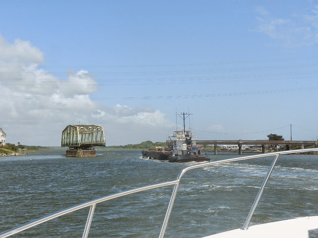
| Approaching the Figure Eight swing bridge at 11:30 AM |
 |
| We clear the first of three swing bridges |
 |
| Surf City swing bridge opened at 1:23 PM for the tow. We followed The bridge tender reported winds at 27 knots. Two down one to go |
 |
| Onslow Beach swing bridge at 3:30 PM |
 |
| Camp Lejune “stoplight” NOT ON!!!! |
The highlight of the day was coaching my friend David on running the buoys on the ICW. David’s last cruise with me was a three day run at the beginning of the Great Loop from Chicago to Peoria in October 2010 on the Illinois River. He hadn’t practiced since and if truth be told he struggled a bit (ok more than a bit). Running the buoys is tricky if you are not an experienced boater. Boats do not handle like automobiles even though both have a steering wheel. The process of keeping the boat within the narrow channel is challenging for the experienced boater. And the channel is narrow, less than 200 feet in places and sometimes down to 50 feet. Not much margin for error.
Coaching David while great fun was actually eye opening for me as it forced me to think about a series of integrated behaviors that the experienced helmsman does instinctively. Essentially I needed to give David an error proof formula. The process boiled down to key elements; following the magenta line, recognizing that the buoys mark the sides of the channel, identifying the next buoy up the line and not going from buoy to buoy, which results in zig zagging to go the edge of the channel. Most important, the helmsman must maintain a scan that includes comparing the movement of the boat to the magenta line to the data provided by the chart plotter and rudder indicator, and, most important, use small adjustments. The key is keeping one’s head out the window and not fixating on the magenta line or the rudder indicator. Oh yes, and once you have a mark in sight, look for the next one, which has become as running joke between David, Dick and I.
The formula worked. David’s steering improved. Most important, I learned that you can’t go wrong following the magenta line (except when the buoys or Active Captain indicate otherwise).
We arrived at the Morehead City Yacht Basin at 7:25 PM. Fueling took another hour. We took on 769.4 gallons at $2.61, the lowest price I’ve paid for diesel EVER I think. Lee’s staying late to fuel us enabled us to leave a 5:30 AM the next day and, as of this writing (at 4:15 PM on Monday off of Long Island), to outrun Tropical Storm Anna.
The absolute highlight of the day was dinner. Dick cooked 6 oz 1 ½ inch filet steaks from Allen Brothers that were INCREDIBLE. I cooked potatoes with garlic and herb de province according to Lesley’s (my daughter’s) recipe. Accompanying dinner was a bottle of 2011 Sequoia Grove Napa Valley Cabernet Sauvingnon that was perfect. Dessert was home-made by Dick’s sister. All in all, the end to a perfect day.
Statistics:
- Distance Today: 91.6 Nautical miles
- Fuel Used: 103 gallons of diesel
- Time Enroute: 11 hours and 35 minutes
- Total Distance: 802.2 nautical miles since leaving Sarasota
- Total Engine Fuel Used since leaving Fort Pierce: gallons
- Total Generator Fuel Used since leaving fort Pierce: gallons
- Fuel Added: 769.4 gallons
- Fuel Price: $2.61 per gallon
- Fuel Cost: $2,008.13
Written by Les.