September 14, 15 2024 At Sea between Pohnpei and Bakawari, Papua New Guinea
Departing Pohnpei about 1930, Seabourn Pursuit continued south overnight. The wind and swell were on the beam, with the seas about 10 feet at 9 second period, so the ship had moderate roll motions. This wave height is typical for the Pacific Ocean, which has an average wave height of 3 meters.
The sunrise was spectacular once again and we had no rain all day. At 1400 we held the Equator crossing ceremony and my sister, Julie, being a Polliwog, was inducted during the ceremony into being a Shellback, so we now had permission from King Neptune to cross the equator with no Polliwogs on board.
Lectures today included one on Seabirds and another on mangrove swamps.
September 15, 2024 – At Sea
September 16, 2024
The Seabourn Pursuit took up position off Bakawari Island, Papua New Guinea at 0600.
 |
Bakawari Island lies next to Bougainville Island
Papau New Guinea |
The ship was cleared by the local authorities about 0700 and Patrick headed off for a Kayak excursion. At 0830, other guests were shuttled ashore in color groups and were treated to a folkloric performance by three local groups on Bakawari Island. The kayak tour finished just in time to be delivered to the beach for the performance.
 |
| Dancing at Bakawari Island |
 |
| Some of the bamboo flutes used by the performers |
 |
| Native canoes fishing |
 |
| Coral formation while kayaking |
 |
| Native Canoe |
By 1200, all guests were back on board and Seabourn Pursuit headed for Honiara, Guadalcanal, Solomon Islands, our next destination. Our route takes the ship down the “Slot”, through Bougainville Straits and past Savo Island before docking at Honiara.
The area we are transiting is larger than we expected. The distance from Bakawari Island to Honiara, Guadalcanal is 335 NM. To make that distance overnight means Seabourn Pursuit has to average more than 15 knots. Fortunately the seas and wind are favorable.
One of the reasons for making this cruise is the opportunity to visit locations in which my father served while in the USN in WWII.
This morning, with calm seas and sunny skies, we are approaching Savo Island and will pass by the final resting place of the USS Astoria, which sank following a fierce night battle just off Savo Island, only two days after the USMC landed at Red Beach on Guadalcanal. The night of August 9, 1942, a night attack by the Japanese navy caught the allies off guard. Four heavy cruisers were sunk, three US and one Australian. Three cruisers were sunk in just a few minutes between 0230 and 0300. The USS Astoria did not sink immediately, but was badly damaged. The crew initially abandoned ship, but later 350 crew returned to try and save the ship. My father was one of those who returned to the ship. He told us about jumping off the bow initially, and returning to collect the bodies of those killed and preparing them for burial by sewing the corpses into hammocks while eating stewed tomatoes since the galleys were unusable and on fire. Initially we were skeptical of some aspects of that story, but when we saw the same story in other eyewitness accounts, we were convinced he had survived a horrific experience.
However, the crews’ efforts were in vain, as underwater explosions in the bow area fatally damaged USS Astoria (my father was aft at that time). The ship was abandoned once again and at 1215 that day, August 9, 1942 the USS Astoria listed 30 degrees, then capsized and sank stern first in 2800 feet of water about 2 miles from Savo Island. More than 247 sailors perished and another 250 were wounded. It was the worst defeat at sea for the US Navy, excluding Pearl Harbor. The USS Astoria was rediscovered by Paul Allen in 2015, in 2800 feet of water, with the bow missing.
 |
| The bridge display as we were at closest point to Astoria |
 |
| Last known phot of Astoria, one day before sinking |
 |
| Photo of Astoria remains by Paul Allen |
 |
| Savo Island |
We wer fortunate to be on the bridge of Seabourn Pursuit when we passed just 2.85 nm from the location of the USS Astoria. We observed several minutes of silence in memory of the hundreds of navy personnel who died in that action on both the Astoria and the other three ships.
My father was then reassigned to the destroyer USS Blue. That ship was torpedoed on August 22, 1942 and scuttled on August 23, 1942, after unsuccessful attempts to save her. My father also survived that sinking.
 |
| USS Blue – DD-387 |
The area between Savo Island and Guadalcanal has been named Iron Bottom Sound, since more than 50 allied and Japanese ships were sunk in the 7 month Guadalcanal campaign. Iron Bottom Sound is considered a sacred place due to all the people who perished and whose remains went to the bottom. Guadalcanal and the Solomon Islands campaigns marked the beginning of the successful, but bloody island hopping strategy which the Allies used to eventually defeat Japan.
The Battle of Savo Island was also a turning point for the US and it’s allies in that the Japanese failed to destroy the troop transports and supply ships lying off of Red Beach, just a few miles from the Savo Island battle, instead withdrawing after destroying the four heavy cruisers. The pattern of tactical victory but strategic mistake would persist throughout the war.
Seabourn Pursuit docked at the container port in Honiara, Guadalcanal at 1100, and by 1140 we were on a bus tour of the Eastern Battlefields of the Guadalcanal campaign.
Honiara is the capital of the Solomon Islands, a sprawling independent nation with more than 95 major islands and a total population of more than 700,000. Honiara has a population of about 65,000. This island nation is being impacted by climate change, with sea levels rising 8 mm per year, more than the average worldwide. The evidence of WWII is still present, with significant amounts of unexploded munitions still being discovered 82 years later.
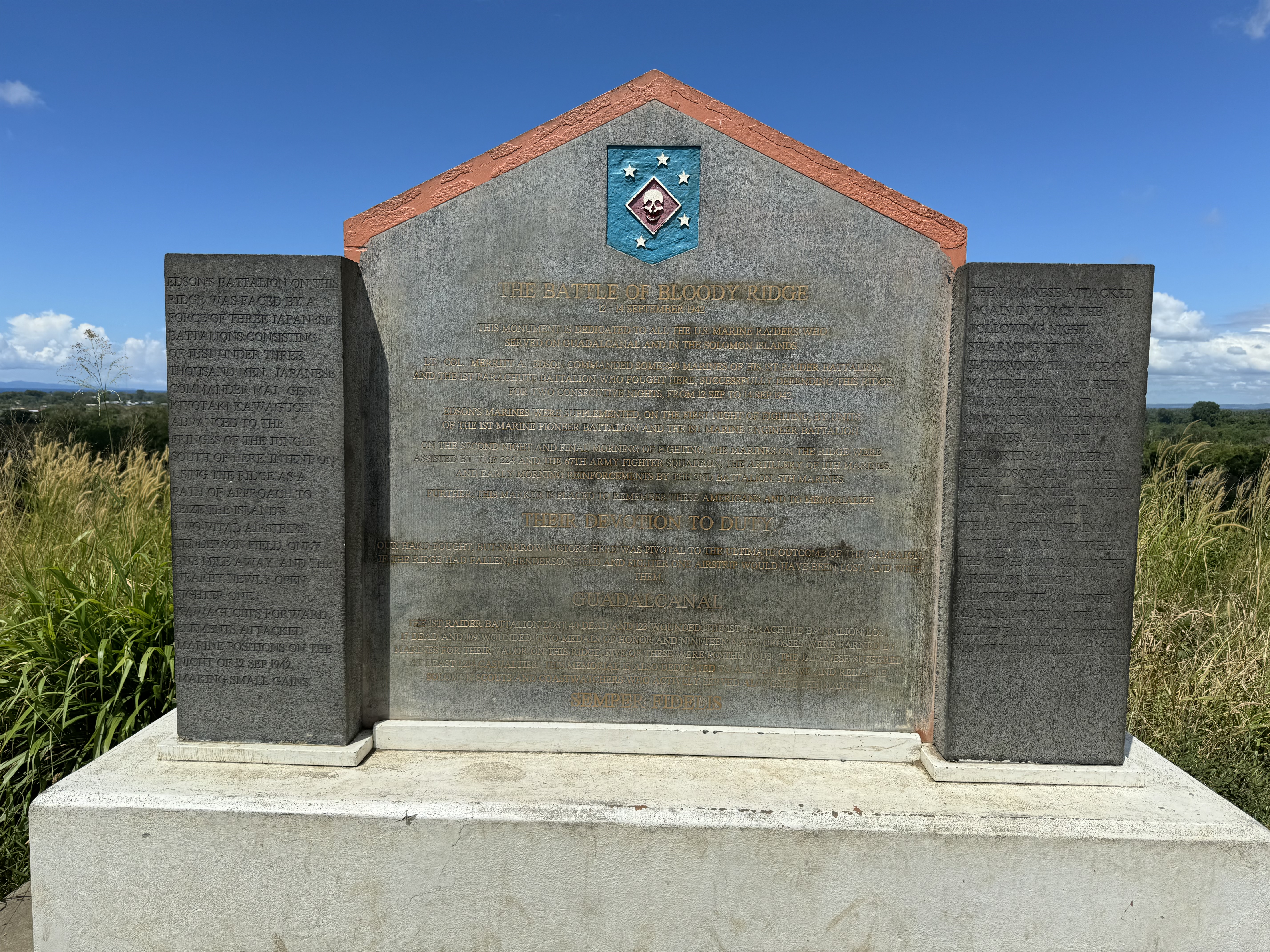
The first tour stop was at Red Beach, where the USMC landed on August 7, 1942, with little opposition. That was soon to change as the USMC took control of Henderson field (our second stop) and set up defensive perimeters, including one at “Bloody Ridge”, our third stop of the tour. We finished the tour with visits to the Japanese War Memorial and the the US War Memorial. The Guadalcanal took seven months to achieve victory, with more than 7,000 Allied deaths and more than 19,000 Japanese deaths.
 |
| Monument at Red Beach |
 |
| Red Beach |
 |
| Memorial Park at Henderson Field |
 |
| View from Bloody Ridge |
 |
| Monument at Bloody Ridge |
 |
| Japanese War Memorial |
 |
| View of Savo Island from US Memorial |
 |
| Battle of Savo Island at Memorial |
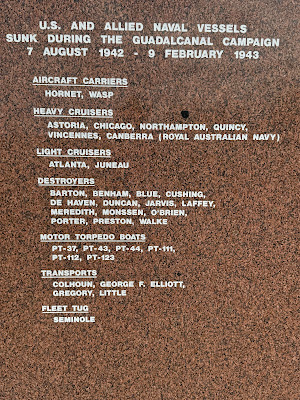 |
| List of US Ships sunk at Guadalcanal |
At 1800, Seabourn Pursuit cast off the lines and continued the journey in Melanesia. Our next port of call is Luganville, Espiritu Santo.