We started the day with a walk to the post office – a one man show in a small town who was out to lunch so we walked to the beach. There we found one lone beachcomber on it bundled up in a blanket reading a book – & I’m sure ho…
Captain’s Log December 27, 2010 to January 11, 2011
Captain’s Log – December 27, 2010 – January 10, 2011
Tonight we are at sea about 850 miles north of Cabo San Lucas. The sea is moderate, with swells about 6 feet and wind waves of about 2 feet, but Odyssey is handling it easily with a sight waddle as…
Gulfport, FL
We started the day with a walk to the post office – a one man show in a small town who was out to lunch so we walked to the beach. There we found one lone beachcomber on it bundled up in a blanket reading a book – & I’m sure ho…
Captain’s Log December 27, 2010 to January 11, 2011
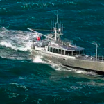
Captain’s Log – December 27, 2010 – January 10, 2011
Tonight we are at sea about 850 miles north of Cabo San Lucas. The sea is moderate, with swells about 6 feet and wind waves of about 2 feet, but Odyssey is handling it easily with a sight waddle as…
Captain’s Log December 27, 2010 to January 11, 2011
Captain’s Log – December 27, 2010 – January 10, 2011
Tonight we are at sea about 850 miles north of Cabo San Lucas. The sea is moderate, with swells about 6 feet and wind waves of about 2 feet, but Odyssey is handling it easily with a sight waddle as…

Part 2 of what we like and don’t like about Sea Spirit
… continued from previous entry.
Fuel system
In addition to having enough fuel capacity (2105 US gallons), I was quite interested in how reliable and convenient the fuel system was going to be on Sea Spirit. As it turns out, the company did nearly e…
Captain’s Log December 27, 2010 to January 11, 2011
Captain’s Log – December 27, 2010 – January 10, 2011
Tonight we are at sea about 850 miles north of Cabo San Lucas. The sea is moderate, with swells about 6 feet and wind waves of about 2 feet, but Odyssey is handling it easily with a sight waddle as…
Dorade vents
Hi Steve,
Happy New Year! I notice on Wind Horse you have used what appear to be PVC cowl / dorade vents.Do you find these superior to stainless steel, and if so, why? I am about to fit the dorade boxes to my alloy Dix43 and need to make the cowl selection. Thanks so very […]
Week13 Jacksonville Ortega River
Installing new heat/AC pumpWe are still in Jacksonville and our wait for our daughter just got longer. She was due to arrive tomorrow (wed) however as in most of the waiting we do, yes its weather related. Providence is due to get 12-18″ of snow tonigh…
Better Than Store Bought
And now for something totally different. Big Run is very well stocked. We have all the necessities. One thing that is difficult to keep onboard are the perishable items such as milk, lettuce and bread. W…