
As I write this we’ve been in Level 4lock down for nearly five weeks now and hopefully we’ll be going down to Level 3 next week and 2 the week after. So let’s hang on in there.
From a boating perspective we haven’t missed out on too much as until the last few days the weather has mostly been miserably wet, windyand chilly. Roll on Level 2, warmer weather and the resumption of boating – we can’t wait!
Here’s an edited version of an article to appear shortly in Pacific PowerBoat re cruising around the Ponui Island area.
In Auckland we’re spoiled for choice of great cruising destinations with about 1,200square miles of the mightyHauraki Gulf and dozens of islands on our doorstep, explainingwhy Auckland is said to have the largest number of boats per capita in the world.
One of ourfavourite inner Gulf islands is Ponui. Maori were the island’s first inhabitants during the 1400s and evidence still remains of 23 separate pa sites. The island was purchased in 1853 by the Chamberlin family, who remained through the generations and still farm the island to this day. Ponui translatesas “long night” and judging from the number of cruisers who frequent this area we’resure there’s been many anenjoyableand long nightspent here.
Ponui is about four miles long in a north to south direction, one to two miles wide and indented with numerous bays and coves offering at least 20 good anchorages, wellspread around the island allowing cruisers tofind safe shelter in all wind conditions. The highly informativeRoyal Akarana Yacht Club Coastal Cruising Handbook (a must have on board for cruisers) provides excellentinformation on most of these anchorages, so we’ll focus on just threeof our favourite areas.
By far Ponui’s most popular anchorage is Chamberlains Bay (also called North Harbour) bordering the northern coast’s Ruthe Passage separatingPonui andRotoroa Islands. This large bay offers great shelter in westerlies through to southerlies and for light north-westerlies and south-easterlies, although in stronger south-easterlies an uncomfortablefetch comes into the bay from the Firth of Thames. You’ll notice that Coastguard have a mooring for their rescue vessels in the bay’s north-west corner.ChamberlainsBay (note spelling of this bay is different to that of the Chamberlin family name) has no particular hazards except for itsmuddy bottom gradually shoalingtowards the southern shoreline. Immediately to the east are two great sandy beaches easily reached by dinghy. If anchoring off these beacheswatch out for the rocky outcrop between the two beaches and monitor your depth. Part of Chamberlains Bay’s appeal is that if the wind shifts to the north or east boats can easily moveless than a mile across to Rotoroa’s South-West Bay to shelter. Thisbay also has three moorings available to rent by prior arrangement at $25 per night. The Salvation Army ran an alcohol addiction treatment centre here from 1911 until 2005 and during that time no landing was allowed. It’s reputed that sometimes desperate alcoholics swam out to boats moored here trying to score a drink. Nowadays visitors are encouraged, but no dogs are allowed as Rotoroa is a wildlife sanctuary with kiwi and weka abounding. It’s well worth visiting their interesting Exhibition Centre and your kids will certainly love the nearby brick jail house. You’ll have to avoid the temptation to leave them there! Takea walk over the island for spectacular views of the Firth of Thames and visit Men’s Bay and Ladies’ Bay on Rotoroa’s east coast – great anchorages in settled westerly conditions. Formerly cruisers could only gazeat these near-perfect beaches from afar, but can now enjoy their white sand, crystal clear waters and gnarly shade-providing pohutukawa trees.
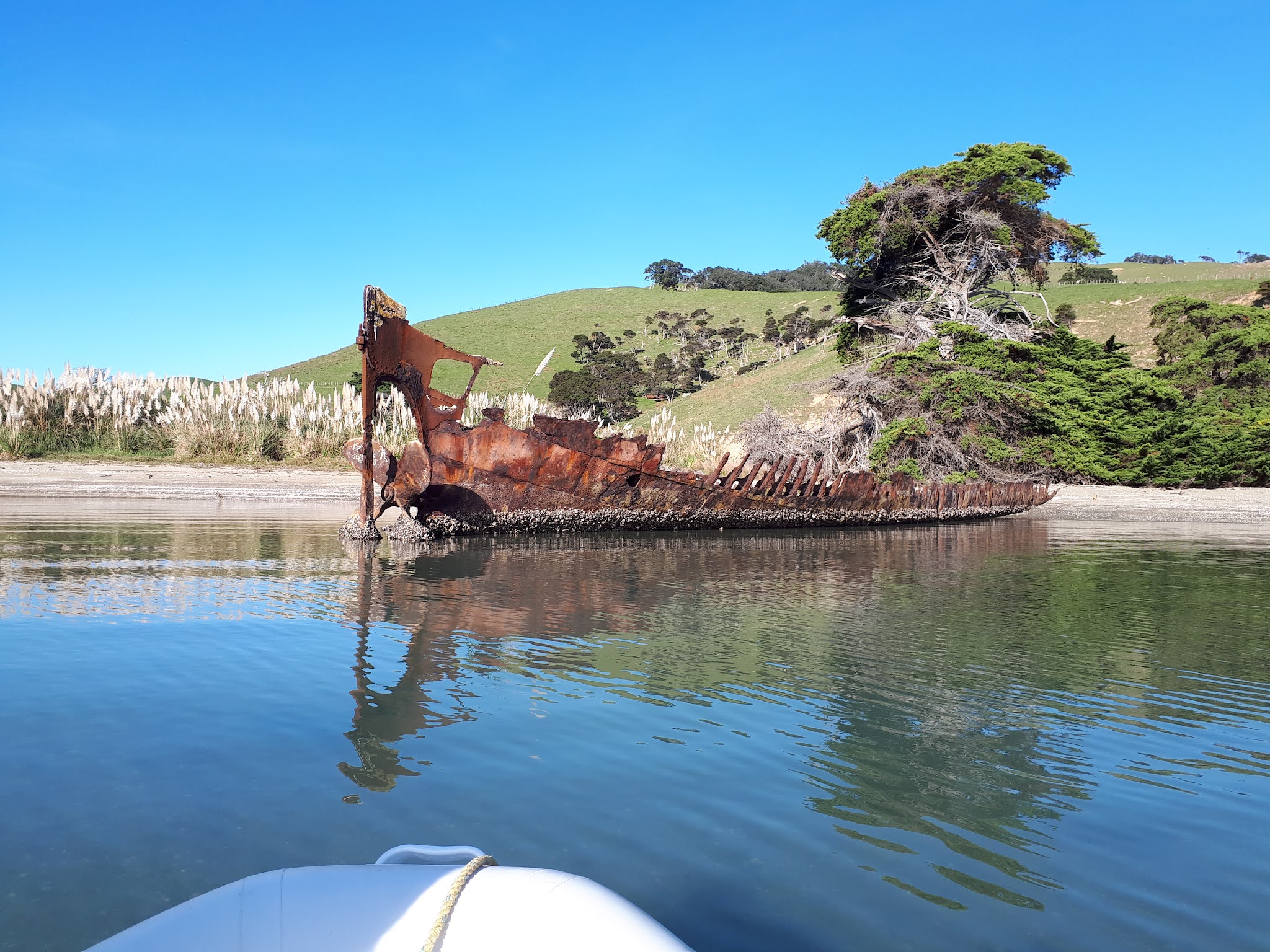
Shark Bay on the island’s western side bordering the Waiheke Channel isn’t mentioned on the NZ 5324Chart for this area, but it’s the bay to the north ofOranga and Poroaki Bays. Oranga Bay is too shallow for anchoring, but take your dinghy in to see the shipwreck on the shoreline with its impressivepropeller and the nearby remains of two boilers. You’ll also see plenty of rays gliding across the seabed searching for kai.
Shipwreck in Oranga Bay on a great early July day
Close up showing the wreck’s huge propeller

Poroaki Bay can be recognised by
Stunning unnamed bay south of Ponui Head

Barge at Poroaki Bay

Bryants Bay on
Fishing is generally good around Ponui, particularly on the eastern side in the Firth of Thames and we’re always able to feed ourselves,however on the north-western side be aware of the Te Matuki Marine Reserve extending across to Awaawaroa Bay on Waiheke Island’s south coast.
There are large signs on PonuiIsland’s foreshores advising the island is private property and that no dogs, fires or camping are allowed. I spoke to one of the island’s three farm owners who advisedboaties mayland on beaches provided they observe the above limitations.Ponui is home to nearly2,000 brown kiwi, descendants of just 13 released in 1964 anddogs and ferrets are theirmain predators so there’s good reason to ban dogs. While most dog owners are responsible a minorityapparently think leashed dogs are not a problem and that rules don’t apply to them. However even leashed dogscanupset farm animals andwildlife whiletheir scent is an issue in bird breeding areas sometimes causing birds to abandon their nests.
There is no fuel, water or supplies available in this area, except for wine at the very pleasant Man O’War Vineyard. On a fine summer’s day you’ll find dozens of inflatables ashore hereenjoying the sandy beach and the selection of winery beverages and snacks. Closest groceries are at Rocky Bay while for fuel and water you’ll have to make the eleven mile trip to Pine Harbour marina.
We really enjoy anchoring in these areas around Ponui and hope you will too, but remember if going ashore to act responsibly by taking no dogs, lighting no fires and taking your rubbish away with you.
Next Post will be about cruising at low rpm without compromising your engines’ performance and longevity.
