On our Christmas
trip to Desolation Sound this year, we were looking forward to testing the boat
in some rough winter weather. We've been out in a few gale
warnings, and the boat has h…
Tag Archives | Nordhavn
Storm Force Winds in the Strait of Georgia
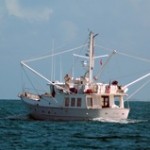
Report From Onboard Jenny
Monday, February 28, 2011 7:31:07 AMLocation: Aquamarina, DaytonaLatitude is 29 degrees 12.093 minutes north.Longitude is 81 degrees 0.745 minutes west.No recent weather observation is available. You know you have found a nice anchorage when the loc…
No-Morewater
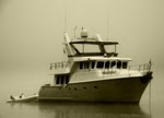
Sadly tonight we said adios to our good friend Peter. The Morewater deal has closed, the deal is done, but today we had a great time running down to Manatee Pocket for lunch at Fins. It was a beautiful day.It’s something we boaters have to do from time…
Report From Onboard Jenny
Friday, February 25, 2011 3:14:36 PMLocation: Rockhouse CreekLatitude is 29 degrees 3.715 minutes north.Longitude is 80 degrees 55.842 minutes west.This weather observation was taken on Friday, February 25, 2011 3:14:15 PM local time.Observation loc…
South Island NZ Countdown
Day 16 – Everyone must be getting tired of this step by step holiday. We are just about ready to go home too. Yes there are lots of things that we haven’t seen; it’s just time to get back to normal again. Sorry for the inundation of blog updates, inter…
Mission aborted
Not the Space Shuttle, but we decided not to drive to Titusville to watch the launch. After a little research on the internet we realized that, thousands of people descend on a small park at about the same time, watch the 90 seconds of the launch, then…
Getting ready for a Bum Clean!
As Monday nears closer we are compiling a variety of items in the lazarette in preparation for our haul out at 7am!! Shock horror! What a ghastly hour of the morning, but we will do it! On the upside, it will be cooler then and as we are doing all the …
Photos 1
Jenny in Ft. Lauderdale. Happy Melinda to be in a City again. We had a good Valentine’s dinner in Ft. Lauderdale! Jenny’s salon at night. Melinda took this great photo of a bottlenose taking a breath. We had a wonderful visit with Tom Lawler on…
Nordhavn Video Featuring Us!
Nordhavn has been making a series of videos to promote their boats. They featured us in one of them, and they even let us talk about the book at the end! Nordhavn Interview with Grabs Sorry we have not been keeping the blog updated. All is well with us; life has just gotten busy. We are […]
An interesting day
Yesterday, Pete invited me over to meet the new owner of Morewater.A nice fellow who brought, Scott Flanders, another Nordhavn owner with him. Many of us long range cruiser types know of Scott and have read about his, and his wife Mary’s, exploits aboa…