VANUA BALAVU (Part 2)

VANUA BALAVU (PART 2)


EAST AND SOUTHEAST
Opua (NZ) – May 6, 2016 –   This is the second installment of my compendium of navigation notes on the Lau Groups, Fiji.
*** Disclaimer – This is a collection of waypoints, anchorages and routes that I have gathered from other cruisers, websites, guides and seminars I attended.  DOMINO has not navigated in the Eastern lagoon of Vanua Balavu and we have not tested these waypoints.  Furthermore, in the aftermath of Cyclone Winston, the seafloor may have been littered with debris and the anchorages may have been altered.  We recommend caution and a sharp lookout, daytime navigation in good conditions only! ***


1 – The Tongan Pass  –  This is the SE pass into Vanua Balavu and the most direct route to Lomaloma.  A reef bisects the entrance of the pass, so cruisers have to go east or west of that reef.  Although I have waypoints for both sides, I have more reports for the west channel.

Tongan Pass – The route entered is for the western channel… The eastern channel is possible as well
2 – Munia Island Anchorage – A good anchorage before or after transiting through the Tongan Pass.
Munia Island Anchorage point
3 – Susui Island – There are 2 anchorages possible – 
Sisui 
4 – The Hidden lagoon – Possibly, the locals at Susui can give cruisers directions to the Hidden lagoon.

Susui Island: Anchorage and Hidden lagoon


Sisui – Hidden Lagoon Anchorage Point – unsure if the lagoon is accessible
5 – Lomaloma to Susui

Lomaloma to Sisui

Lomaloma to Sisui, and Munia Island

6 – Tongan Pass to Lomaloma

Tongan Passage to Lomaloma

7 – Lomaloma anchorage – 

YanuYanu = Lomaloma

8 – Mavana – 
Mavana Anchorage

9 – Lomaloma to Mavana –   
Lomaloma to mavana
Again, we have not experienced these anchorages and we expect they have most suffered from a 30’ surge and 165 mph winds.  I wish I had recent Google satellite pictures to share, but all of these are pre-Winston.  
In any case, be careful!
Until next time

dominomarie

Vライン限定の脱毛の場合は…。

フェイスとVIOライン脱毛のどちらもが含まれた上で、何よりも低料金の全身ミュゼなどの脱毛コースを頼むことが必要…

My brother Dave

Dave and Mary Margaret have sailed around the world in their catamaran Leu Cat. A link to their blog is on the side. You should visit. They are awesome sailors. But, Dave is an amazing blogger, blogging nearly every day of their 8 year journey. He…

VANUA BALAVU (Part I)

VANUA BALAVU – West and North
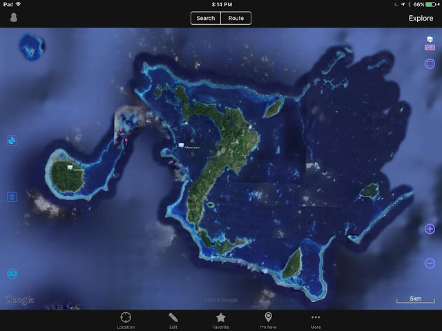
Vanua Balavu, Northern Lau Group, Fiji
3 passes: Qiliqili to the NW, Adavaci to the W, and Tongan Pass to the SE
*** Disclaimer  — These navigation notes have been gathered from many sources as well as from our own experience.  After Cyclone Winston, we can expect that many navigation beacons and marks have disappeared.  We can also expect that, in some places, the coral beds have been damaged and perhaps re-arranged.  The litter and rubble in the anchorages is unknown.  Use the provided information using your own discretion, and keep a sharp lookout.  Do not navigate inside the lagoons and passes in poor visibility.  ***

Note that DOMINO draws 1.2 meter (4′) – 

QILIQILI PASS (NW PASS)
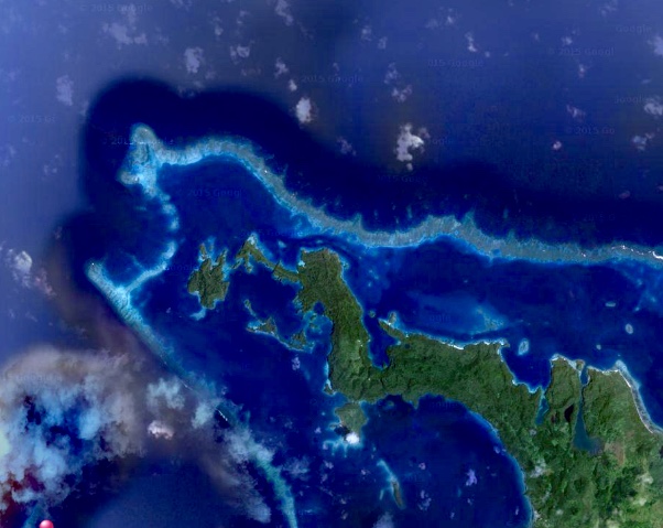
Qiliqili Pass (NW end)

  • Photo 1 – Vanua Balavu – General Location of Northwest pass entrance (Qiliqili) 
(NOTE – iSailor files may still be available for download on my Google Drive )


  • Photo 2 – Vanua Balavu NW Pass (Qiliqili) to Delaconi village – Waypoints 3-11


  • Photo 3a – Vanua Balavu – Domino’s track from Qiliqili Pass to Delaconi anchorage

** CAUTION **  Be mindful of the small reefs when approaching the village  –  The holding at Delaconi village is marginal, lots of rocks and rubble.  It is rolly in any SW to NW condition.   Then, a better anchorage can be found just west of the airstrip.
  • Photo 3b – Delaconi – Airstrip anchorage

A bit of a dingy ride to the village, but the “airstrip” anchorage is popular in westerly conditions
Getting to shore by dinghy, look for the small opening in the reef, not wide but present at low tide… not no much worry at high tide. 
ADAVACI PASS (SW PASS)
  • Photo 4 – Vanua Balavu – Adavaci Pass (SW) – Waypoints 1-7 – This is a straight shot west of Delaconi Village.  One of the reasons while the anchorage is rolly in westerly conditions, but a quick way to get out.  At any rate, only advisable in calm and clear conditions as there are bits of reef to be avoided.
Photo 5 – Vanua Balavu Adavaci Pass (SW) – Detail – WP 3-6
                 (The orange food cart denotes good fishing!!!)


BAY OF ISLANDS
When the anchorage in Delaconi gets too rolly and windy, the Bay of Islands (BoI) offers good protection from most directions.  Some yachts may find it hard to anchor in the 17-20-meter depth, but the holding is good.  With a bit of poking around, you can find shallower spots.
To get to the BoI anchorages from Delaconi, we found it safer to track back towards Qiliqili Pass and enter the “dogleg” track.  Always trolling a couple of lines, always catching a Sierra (Spanish Mackerel) or two!
We’ve seen some yachts take the shorter “inside passage”, but only with excellent visibility and 2 lookouts on deck, and it’s a gutsy passage I would’t try.  S/Y Rewa did it and we watched them hesitate and backtrack between rocks and reefs! 
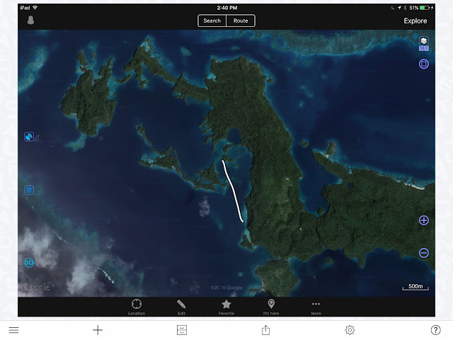
The “Inside Passage” to the BoI – Not recommended!
Photo 6 – Bay of Islands “Dogleg” and Domino’s track

Photo 7 – Bay of Islands Anchorages – There are many of them in The “Swimming Pool”, but there is no need to be on top of each other.  It’s a wonderful area to explore, find the caves, look for the fruit bats, and kayak around.  The nook at the northern end is a good overnight spot while waiting for good conditions to exit.  Note that the “Front” and “Rear” beacons are most likely gone.


BAY OF ISLANDS TO MBAVATU (PLANTATION) 
Photo 8 – DOMINO’s track – to enter Mbavatu, use Wpts. 2 and 1
** Note that at the northern end of the island, the reef extends farther out than on the chart.  Keep a sharp lookout… most of the marks may have disappeared ***


Photo 9 – Rounding over the top… notice the reefs in the north channel… careful… only do on a clear day!
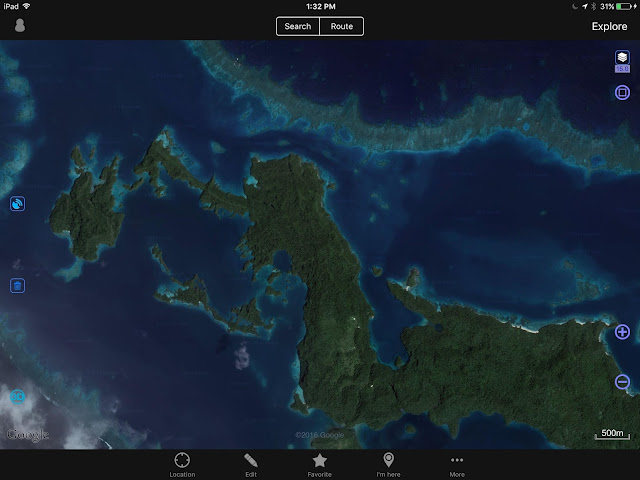
OVITALMAP satellite photo

Photo 10 – Mbavatu Harbor – There are several anchorages, but the closer you get to shore, the more likely you are to encounter rocks.  Also, the anchorage in the NE hook has been proven to get rolly as the rocky shores reverberate and amplify any kind of wave action.  We just prefer to anchor smack dab in the middle!  The “Yacht Club” moorings on the Western end may be gone, the Yacht Club building too… The Landing is at the bottom Western side of the bay.  Just walk up the hill and you should get to the coconut oil plant, or what’s left of it.  Higher yet is the coconut plantation and workers’ village… if still standing.

Photo 11 – Mbavatu Harbor
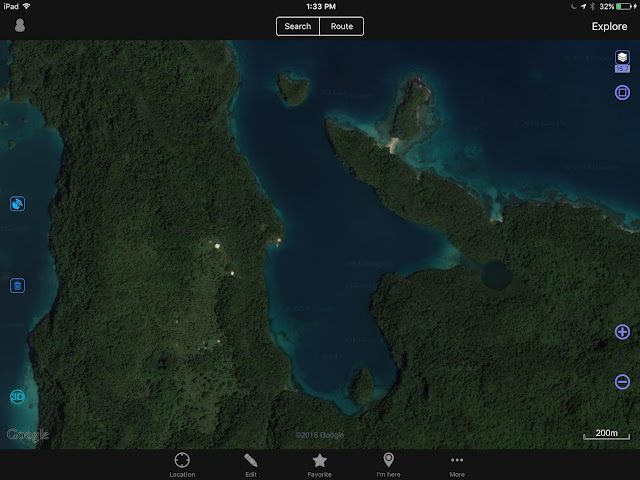
OVITALMAP


Photo 12 – Horse Bay and Little Bay

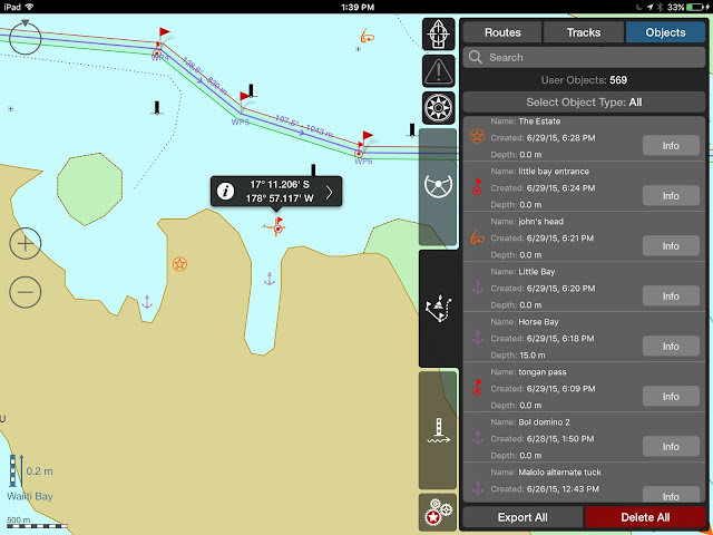
Horse Bay, Little Bay, The Estate and other waypoints

Photo 13 – Horse Bay “The Estate” was a pig farm.  What is left, we do not know.  It is possible to anchor – 17*11.527S – 178*57.710 W


Photo 14 – Little Bay – It is possible to enter Little Bay – It used to have good Internet, in straight line from the phone tower, but who knows what happened with the comm. tower?  Very secure anchorage, not much room for more than 1 boat.


Photo 15 – Mbavatu to Avea – Again, careful of the reef, especially around WP7 – 


Photo 16 – Avea Anchorage – Just north of the village, the anchorage can be rolly, and we only stayed one night.  The village was so low-lying it’s probably gone. 


There is good snorkeling just north of the anchorage and Soggy Paws reported good diving just through the pass 
( WPs: dinghy pass Inner 17*10.349S 178*54.429W
            dinghy pass Outer 17*10.315S 178*54.447W
            Dive spot 17*10.239S 178*54.504W ) What is left?
Photo 17 – Avea – The village is located at the SW tip of the island.


till next time

dominomarie

2016-08 Fish Egg, Shearwater to Uncharted Lambard Inlet

Thursday, May 5, 2016This morning we harvested more seafood.  With 12 crab it was time to cook and pick.  After 50 prawns had their heads twisted off, a prawns and pasta dinner was likely.  Maybe crab cakes for appetizers? We motored up …

New Zealand to Fiji


NEW ZEALAND TO FIJI
After last cruising season in Fiji (May to November) and our forced migration to New Zealand to repair hull damage (a reef scratched our bottom!), we were planning on spending another season lazing around the coasts of Vanua Levu (Fiji’s North Island), diving the splendid reef of the Somosomo Straight.  But Winston changed all that.

On February 20th, Cyclone Winston —A Cat. 5 Cyclone, the strongest cyclone to hit the South Pacific on record — slammed into Fiji.  After skirting Fiji as a Cat. 2 cyclone, Winston travelled east toward Tonga, then made a 180 degree turn and tracked back toward Fiji, gathering strength.  It slammed into Vanua Balavu (Northern Lau Group), unleashing winds at 165 mph and even a recorded gust at 190 miles/hour (306 km/h) and created a 30-foot (10 meter) surge that swamped roads, homes, schools, entire villages.  
An amazing track: Winston travelled SSE, then NE, then tracked back full West…

Winston continued its track west at 25 Kts, roaring over Taveuni and slamming into Savu Savu with sustained winds recorded at 145 mph (230 km/h.)  Of the 52 boats in Savu Savu harbor, only 7 remained at anchor or on their moorings.  All others were either washed ashore (some washed up 200 yards inland) or sunk.  Our friends on Kaija’s Song lived to tell the horror of that night.  Thanks to rapid help, Savu Savu is recovering; so is the mainland of Vanua Levu.  Taveuni, accessible through its air strip, is also receiving help.  

In Savu Savu, utter destruction!

But what of the Northern Laus and Vanua Balavu?  Isolated, absolutely devastated, Vanua Balavu and its surrounding islands are a long way from recovery.  Some islands have not had any damage assessment yet.
The Lau Group, especially the islands in the north, Vanua Balavu and its surrounding isles were hardest hit
We wanted to do something for the Fijians in the Northern Laus, who have welcomed us so warmly last season.  But how to help?  In comes SEA MERCY, a 4-year old relief organization made of volunteer cruisers.  Strong of their experience in Vanuatu last year (Cyclone PAM devastated some areas of Vanuatu,) SEA MERCY is organizing a fleet of boats to spread all around Fiji and bring help to isolated villages.  Our particular group, DR2A (Disaster Recovery Group 2A) is awaiting a weather window to head straight for Vanua Balavu where Sea Mercy has organized an exceptional clearance from the customs and immigration officials, though VB is not a normal port of entry.  
In Vulaga (Southern Laus) exporting clams is a sustainable commerce
Several more groups have formed in Opua (New Zealand) and will leave either for Denarau (South Island of Viti Levu) or Savu Savu (North Island of Vanua Levu), while other vessels will arrive from other points (Australia, French Polynesia) and join the Sea Mercy fleet for the season.  In all, some 40 yachts are involved in this massive recovery effort.
Weather GRIB on Predic Wind
While we are waiting for the large stationary high pressure system currently hovering over New Zealand to dissipate, and for weather window to open (looks like a May 11th departure), we are getting the boat’s communications ready, gathering waypoints and alternate routes with a stop-over at Minerva Reef.
COMMUNICATIONS
Our new setup: Iridium 5555 + Optimizer
  • IRIDIUM + OPTIMIZER  –  The latest toy from Iridium is the IRIDIUM GO, a satellite WiFi hotspot with integrated GPS.  But since our IRIDIUM 9555 handset is in excellent working order, we were not on the market for a new satphone.  Enter the OPTIMIZER by RedPort, a little gizmo that plugs into the IRIDIUM handset and turns it into a WiFi hotspot.  It comes with the X-Gate mail program and works seamlessly with our iPads and Macs.  
PHYSPLOT: Our old set up: still valuable information, still will use it
  • Why would we want this anyways?  Isn’t our old system of Windows-based weather GRIBs and Physplot Fleet Code plotting enough?  Could be, and we are definitely keeping that option as backup.
   For the last 2 years, while on passages, our daily mail (using X-Gate Mail) requests to saildocs under this setup have been- (and this is our back-up option now)
subject: (blank)
body:  send fleet.nadi
           send gfs:10S,40S,165E,165W|2,2|24,48,72,96|
( * more saildocs GRIBS available at  gribinfo@saildocs.com
   * for a list of saildocs documents available, send an email
   subject: (blank)
   body: send index
The robot responds within seconds and we drag the “Fleet NADI” email onto the Physplot  program (more on the Pangolin Website) to see the current pressure chart for the South Pacific.
As for the “GRIB” email, all we have to do is open the attachment and it opens itself into the GFS reader.
A bit cumbersome, but it works well enough… now, for the new and improved and FASTER (saves minutes on the IRIDIUM plan)…
  • PREDICT WIND – The new rage in passage weather routing, PREDICT WIND rocks!  Fully integrated with the IRIDIUM GO (or IRIDIUM + OPTIMIZER) and the X-Gate Mail, Predict Wind offers offshore weather routing and GRIB files in quick download formats.  Just prepare the email off-line using the Predict Wind Offshore App, fire-up the IRIDIUM hotspot, and BANG! in a matter of seconds you have your GRIB file, pressure map, and updated routing info.  You can enter the parameters of your boats for maximum efficiency or comfort, and tweak your “POLARS” to your liking.  Pretty nifty!
      

         MET BOB –  For years, we have subsribed to METBOB’s weekly weather report.  Once again, Bob McDavitt is helpful as he is analyzing the weather for our group’s passage!


  • Good old HAM Radio – 

  •  PACIFIC SEAFARERS NET (14300 kHz @0300 UTC) – Still our favorite.  The many operators and relays ensure the clearest possible communication with Americans.  No weather info unless requested. Track our progress on the Pangolin YOTREPS

  • GULF HARBOR RADIO (8752 kHz @ 1915 UTC) – David and Patricia run weather and roll call, a nice volunteer service.  I’ve had difficulty understanding the Kiwi accent, however, and I’ve found the net to run longer than comfortable.  Track us on the AIS tracker. 
  • SOUTH CROSS NET (8191 kHz  @ 2000 UTC) – A small group of cruisers between NZ and Fiji share their positions and weather info.
  • NORTHLAND RADIO (6227 kHz @ 0610 UTC) – Private Radio station in Russell

OVITALMAP – Faster download, better resolution than SAS Planet and Open CPN/Google
Amazing to watch your boat navigate into a harbor or through the reef!
CHART PLOTTING – The apps for iPad and Mac keep popping up!  Try OVITALMAP for iPad.  The app uses the GPS location of your iPad to locate the boat on a satellite photo.  You can choose either Google or Bing – Since we don’t have broadband Internet on passages, we cache images of all intended destinations before we leave home port.  Unlike the SAS Planet or Open CPN programs that ask you to cache the downloaded images, OVITALMAP automatically saves all images as you explore the area.  It’s lightning-fast!  Zoom in, zoom out, it’s all saved!  One caveat: check on the storage volume of you iPad!
I love iSailor!  so easy to share routes and tracks with other users!
I can just take a photo or export to my Google Drive for all to use!
TEST IF IT WORKS FOR YOU  at My Drive….
For navigation, we still use the ship’s Navnet system (although it’s very inaccurate in the Lau Group), Navionics for iPad, and (my favorite) iSailor for iPad.  Do we have enough info?  Right!  The danger is now that we spend too much time looking at the screens, not enough time looking out the window!!! BEWARE!!!

A note:  The Island Cruising Association (Opua, NZ) has published an app to help cruisers with their Fiji travels, with some good weather planning info, some commonly travelled routes and waypoints, a cruising guide app worth a look.


CRUISING GUIDES – For Fiji, we have used Soggy Paws’ Compendium, and scores of blogs and notes gleaned from the Internet.  There is precious little info on the Lau Group.  For this reason, I will dedicate the next blog to the Laus, routes and waypoints.
The Fijians have made us feel at home.  We are ready to rebuild their homes!
CONTRIBUTORS –   I would be remiss if I didn’t acknowledge the locals and internationals who are helping our Sea Mercy fleet.  Particular thanks go to
– the Island Cruising Association for sharing their knowledge and meeting space.
– ITM  for providing us with shelter building kits and solar lights
– BURNSCO  for loading us with fiberglassing kits and fishing supplies
– METBOB for his weather routing
– The Satphone Store for helping us solve our communication issues
– The Wirie  for keeping our WiriePro in good working order and updating its software

… and Jonathan on S/V Chez Nous, our tireless leader and coordinator!

We are ready to go! 
Until then…

dominomarie

FPB 78-1 Update: Wrestling With Art

Now we get to the hard part, choosing art work and photographs for the many surfaces aboard Cochise.  Most of …Read More

On To Puerto Rico

I’m enjoying a day of rest today after tramping all over the place yesterday sight-seeing in Puerto Rico. We sailed here a few days ago when the weather forecast was favorable, enjoying a mellow 40 Read More …

Pender Harbour to Shoal Bay

May 3, 2016Our 0500 planned departure for Princess Louisa Inlet was delayed since we were all tired and the wind and rain made a departure before daylight less than appealing.  Several hours later we checked the weather forecast, which had deterio…

Vancouver to Pender Harbor

May 1, 2016

The skies were clear and the winds light as we decided what to do.  Spirit needed rinsing from the crossing the day before, oysters needed to be purchased on Granville Island at “The Lobsterman”, and some specialty spirits awaited at the Coal Harbour Liquor Store, close to the finish of the Vancouver Marathon.  We also planned to partake of “Tappy Hour” at Provence Marinaside later in the afternoon.

The weather continued to be clear and sunny, with just enough breeze to keep the temperatures comfortable, so snagging an outside table at the restaurant was a pleasant choice.

Supper later on was in courses between rounds of Mexican Train, and we had the ray oysters purchased earlier in the day, along with shrimp and salad and a fresh baguette.

May 2, 2016

Another sunny day greeted us as we filled the tanks with water and cast off the lines at 0800.  Heading out False Creek we prepared to put the Grady White in tow outside the Granville Street Bridge and realized we had not returned the key fobs, so at 0820 Patrick ran back to the marina in the tender while Miriam, Ted and Lisa continued on course to Pender Harbour.  
Patrick’s round trip took about 45 minutes due to the 5 knot speed restriction in False Creek, but shortly after 0900 the tender was back alongside and Spirit continued north to Pender Harbor under sunny skies and calm seas.

Entering Pender Harbour we brought the tender back alongside and anchored in Gerrans Bay at 1442, having covered 46 nautical miles.  Following a tour of Pender Harbour in the tender, under warm sunny skies, we then grilled pork chops marinated in pineapple habanero sauce for our main course. 
Rainbow over Pender Harbour before the rain began

Later that evening, the wind shifted to the north and the rain began, sometimes hard.